25th Annual Black Diamond Fall Fundraising Party
Thursday, September 13; 6:00-10:00 PM; Black Diamond Parking Lot
25th Annual Black Diamond Fall Fundraising Party
Thursday, September 13; 6:00-10:00 PM; Black Diamond Parking Lot
| Advisory: Logan Area Mountains | Issued by Toby Weed for Wednesday - November 30, 2016 - 6:21am |
|---|


|
bottom line Heightened avalanche conditions exist on drifted slopes at upper elevations in the backcountry. Pockets with more dangerous deep slab potential might be found in drifted north facing terrain on steep slopes with underlying smooth ground and weak snow preexisting before Thanksgiving.
|
 |
special announcement USU Outdoor Program is hosting a free Know Before You Go Avalanche Awareness talk tonight! 11-30-2016. more info go.. HERE You are invited to our annual Pray for Snow fundraiser/party on Wednesday December 7 at the Italian Place in downtown Logan. For tickets and information Go...HERE |
 |
current conditions The Tony Grove Snotel at 8400' reports significant accumulations of new snow containing 2 inches of SWE (snow water equivalent) from the Sunday/Monday storm, and there's now about two feet of total snow on most slopes in the area above about 8000'. It's 9 degrees at 9700' at the CSI Logan Peak weather station, and I'm reading a very light breeze out of the south-southwest, but mostly calm conditions. You'll find fast riding in nice fresh powder at upper elevations in the backcountry, and lower angled slopes are fun. Careful because there is still no solid base to keep you off the rocks. Remember, the Tony Grove Road is a busy shared use area, so you have to watch your speed around pedestrians and dogs. The road is not maintained for driving in the winter and conditions deteriorated significantly with the storm in the past couple days. If you attempt the drive in your 4x4, be prepared with shovel and winter survival gear. Beaver Mountain welcomes up-hill traffic this time of year as it helps to pack out the slopes, but you should consider it as "backcountry terrain" before they open the lifts to the public. |
 |
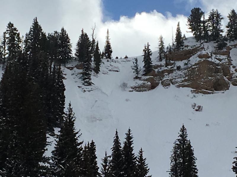
recent activity Yesterday, I could see evidence of a good sized natural avalanche on a due north facing slope at around 8700' in East Miller Bowl. The avalanche on a very steep drifted slope was about 2 feet deep and around 40' wide, and it ran a good ways down the bowl into trees below.
A fresh natural avalanche on the east side of Miller Bowl (photo from 11/29/2016 |
| type | aspect/elevation | characteristics |
|---|

|
|
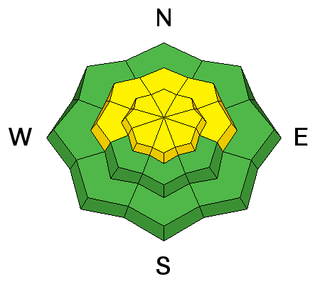
LIKELIHOOD
 LIKELY
UNLIKELY
SIZE
 LARGE
SMALL
TREND
 INCREASING DANGER
SAME
DECREASING DANGER
|
|
description
Although wind slabs are gaining strength and becoming more difficult to trigger, heightened avalanche conditions persist on steep drifted slopes at upper elevations after the blustery storm earlier in the week. |
| type | aspect/elevation | characteristics |
|---|

|
|
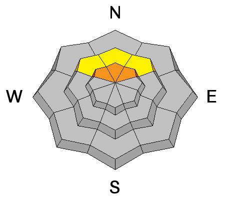
LIKELIHOOD
 LIKELY
UNLIKELY
SIZE
LARGE
SMALL
TREND
 INCREASING DANGER
SAME
DECREASING DANGER
|
|
description
Pockets with more dangerous conditions can be found at upper elevations. Deep slabs, failing on old faceted basal snow are still likely on some north facing slopes with smooth underlying ground and recent accumulations of wind deposited snow. Pay attention to signs of instability like cracking or collapsing. |
 |
weather A cold northerly flow over the area this morning will give way to weak high pressure this afternoon. The next storm system will begin to spread into northern Utah Wednesday night and slowly cross the region through Friday morning. |
| general announcements The early season is a great time to refresh yourself and practice companion rescue techniques with your partners. Check out Avalanche Canada's "Rescue at Cherry Bowl" story HERE Between now and Jan 15th: Donate to the Utah Avalanche Center by shopping at Whole Foods Market Utah! When you visit any Utah Whole Foods Market locations, bring your re-usable bags, Whole Foods will donate a dime per bag to the Utah Avalanche Center - if you say DONATE my bag credit. Remember your information can save lives. If you see anything we should know about, please help us out by submitting snow and avalanche conditions. You can also call us at 801-524-5304, email by clicking HERE, or include #utavy in your Instagram. This advisory is from the U.S.D.A. Forest Service, which is solely responsible for its content. This advisory describes general avalanche conditions and local variations always exist. |