25th Annual Black Diamond Fall Fundraising Party
Thursday, September 13; 6:00-10:00 PM; Black Diamond Parking Lot
25th Annual Black Diamond Fall Fundraising Party
Thursday, September 13; 6:00-10:00 PM; Black Diamond Parking Lot
| Advisory: Logan Area Mountains | Issued by Toby Weed for Saturday - November 26, 2016 - 6:34am |
|---|


|
bottom line Very shallow early season snow cover exists in the backcountry, and hitting rocks is perhaps more a concern than potential avalanche danger. Even so, small triggered persistent slab avalanches may be possible on smooth north facing upper elevation slopes with preexisting snow. You don't want to take a ride even in a small avalanche, as you could easily be injured with the shallow snow hardly covering up the rocks and dead-fall in avalanche runout zones.
|
 |
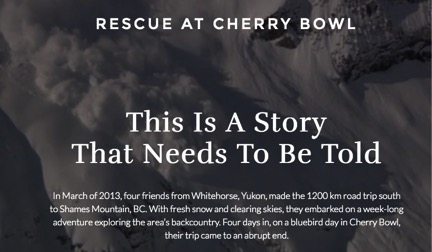
special announcement USU Outdoor Program is hosting a free Know Before You Go Avalanche Awareness talk on Wednesday night, 11-30-2016. more info go.. HERE You are invited to our annual Pray for Snow fundraiser/party on Wednesday December 7 at the Italian Place in downtown Logan. For tickets and information Go...HERE Fresh from Canada.....
Check out the story HERE |
 |
current conditions Expect to find very shallow early season conditions, with all but due north facing slopes completely bare of snow before last week. There's only a few inches covering the rocks up at Tony Grove, and 9 inches of total snow on the ground at 8200' at the Franklin Basin Snotel just north of the state line. It's 27 degrees this morning at 9700' on Logan Peak, with sustained 30 mph winds overnight from the south-southeast. Remember, the Tony Grove Road is a busy shared use area, so you have to watch your speed around pedestrians and dogs. The road is not maintained for driving in the winter, so if you attempt the drive in your 4x4, be prepaired with shovel and winter survival gear... The early season is a great time to refresh yourself and practice companion rescue techniques with your partners. |
 |
recent activity A party in the Tony Grove Area reported some subtle audible collapsing in north facing terrain at around 9000' on Thanksgiving Day. No avalanches were reported locally, but a skier triggered avalanche and a small natural avalanche cycle occurred this week at upper elevations in the Central Wasatch Range... |
| type | aspect/elevation | characteristics |
|---|

|

|
LIKELIHOOD
 LIKELY
UNLIKELY
SIZE
 LARGE
SMALL
TREND
 INCREASING DANGER
SAME
DECREASING DANGER
|
|
description
Although the wind slabs from Thanksgiving are now fairly well bonded to the ground or shallow preexisting snow, sustained south winds overnight may have created a few stiff drifts in exposed upper elevation terrain. |
| type | aspect/elevation | characteristics |
|---|
|
|
|
LIKELIHOOD
LIKELY
UNLIKELY
SIZE
 LARGE
SMALL
TREND
INCREASING DANGER
SAME
DECREASING DANGER
|
|
description
Small persistent slab avalanches may be possible on isolated north facing smooth slopes at the highest elevations. |
 |
weather Warm and dry conditions today will be followed by a series of storms impacting the region tonight through Tuesday. These storms will bring much colder temperatures and wet conditions to the area through midweek. |
| general announcements Between now and Jan 15th: Donate to the Utah Avalanche Center by shopping at Whole Foods Market Utah! When you visit any Utah Whole Foods Market locations, bring your re-usable bags, Whole Foods will donate a dime per bag to the Utah Avalanche Center - if you say DONATE my bag credit. Remember your information can save lives. If you see anything we should know about, please help us out by submitting snow and avalanche conditions. You can also call us at 801-524-5304, email by clicking HERE, or include #utavy in your tweet or Instagram. |