25th Annual Black Diamond Fall Fundraising Party
Thursday, September 13; 6:00-10:00 PM; Black Diamond Parking Lot
25th Annual Black Diamond Fall Fundraising Party
Thursday, September 13; 6:00-10:00 PM; Black Diamond Parking Lot
| Advisory: Abajo Area Mountains | Issued by Eric Trenbeath for Thursday - March 15, 2018 - 7:23am |
|---|

|
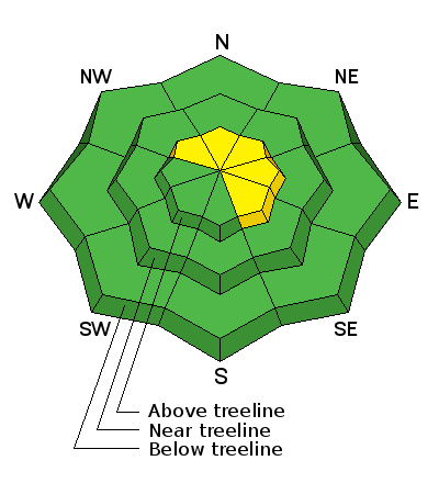
bottom line The avalanche danger is generally LOW this morning but could rise to MODERATE this afternoon as wind and blowing snow form shallow wind slabs on the lee sides of ridge crests and terrain features in upper elevation, wind exposed terrain. Be alert to changing conditions and be on the lookout for recent deposits of wind drifted snow. It may still be possible to trigger an old hard wind slab, or persistent slab avalanche up to 3' deep on a buried weak layer of sugary, faceted snow. The most likely areas to trigger an avalanche are on steep, wind drifted slopes right around treeline and above that face NW-N-NE.
|
 |
special announcement Episode 6 of the UAC podcast "A Conversation with Tom Kimbrough" is live. We explore ideas about lifetime exposure to risk and what role Buddhism has played in his life as a climber, skier, and soon-to-be octogenarian. We talk about what has changed over the years in snow science and the role of mentorship in the world of avalanche forecasting and other professions and pursuits. Check it out on ITunes, Stitcher, the UAC blog. The UAC Marketplace is still open. Our online marketplace still has deals on skis, packs, airbag packs, beacons, snowshoes, soft goods and much more. INSTAGRAM! We now have a UAC-Moab Instagram page. You can find it here....but better yet follow us on your smartphone. Confused? Ask a teenager. |
 |
current conditions Wind and sun have been hard on this year's thin snow pack and it's dwindling rapidly since the last significant storm cycle now more than two weeks ago. South facing slopes are melting out to the ground, and general cover on shady aspects is 2-3'. Kevin Dressell was up yesterday and sent in this report on the end of winter. Let's hope the storm this weekend will prolong it a little more. Wind, temperature and humidity on Abajo Peak (11,000') Snow totals at Buckboard Flat (8924') Snow totals at Camp Jackson (8858') Horse Head Mountain and the view west from North Creek Pass. |
 |
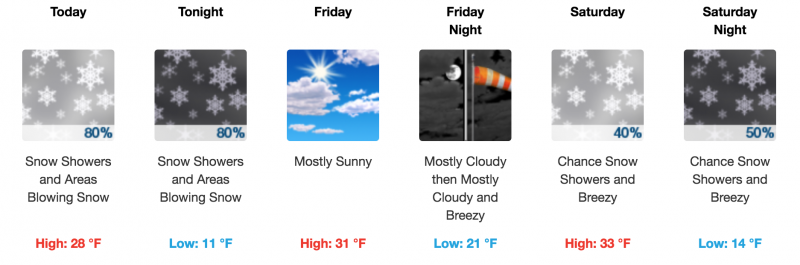
weather Today look for snow showers and periods of blowing snow mostly after noon. 2-4" are possible. Blustery SW winds will be on the increase averaging 30-35 mph along ridge tops. High temps at 10,000' will be in the high 20's.
|
| general announcements The UAC has new support programs with Outdoor Research and Darn Tough. Support the UAC through your daily shopping. When you shop at Smith's, or online at Outdoor Research, REI, Backcountry.com, Darn Tough, Patagonia, NRS, Amazon, eBay a portion of your purchase will be donated to the FUAC. See our Donate Page for more details on how you can support the UAC when you shop. Benefit the Utah Avalanche Center when you buy or sell on eBay - set the Utah Avalanche Center as a favorite non-profit in your eBay account here and click on eBay gives when you buy or sell. You can choose to have your seller fees donated to the UAC, which doesn't cost you a penny This information does not apply to developed ski areas or highways where avalanche control is normally done. This advisory is from the U.S.D.A. Forest Service, which is solely responsible for its content. This advisory describes general avalanche conditions and local variations always occur. |