25th Annual Black Diamond Fall Fundraising Party
Thursday, September 13; 6:00-10:00 PM; Black Diamond Parking Lot
25th Annual Black Diamond Fall Fundraising Party
Thursday, September 13; 6:00-10:00 PM; Black Diamond Parking Lot
| Advisory: Abajo Area Mountains | Issued by Eric Trenbeath for Saturday - March 10, 2018 - 6:56am |
|---|

|
bottom line The avalanche danger is generally LOW but low danger doesn't mean no danger. It may still be possible to trigger an avalanche on a buried weak layer of sugary, faceted snow near the ground, and backcountry travelers need to continue to maintain a standard level of avalanche awareness. The most likely areas to trigger an avalanche are on steep, wind drifted slopes at upper elevations that face NW-N-NE. Ride slopes one at a time, and stay out from under run out zones when someone else is on the slope.
|
 |
special announcement Episode 6 of the UAC podcast "A Conversation with Tom Kimbrough" is live. We explore ideas about lifetime exposure to risk and what role Buddhism has played in his life as a climber, skier, and soon-to-be octogenarian. We talk about what has changed over the years in snow science and the role of mentorship in the world of avalanche forecasting and other professions and pursuits. Check it out on ITunes, Stitcher, the UAC blog. The UAC Marketplace is still open. Our online marketplace still has deals on skis, packs, airbag packs, beacons, snowshoes, soft goods and much more. INSTAGRAM! We now have a UAC-Moab Instagram page. You can find it here....but better yet follow us on your smartphone. Confused? Ask a teenager. |
 |
current conditions
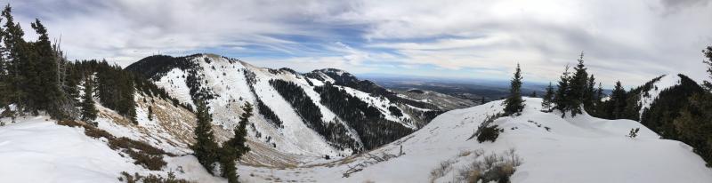
A few high clouds are streaming over the area, WNW winds are averaging 10-15 mph along ridge tops, and 10,000' temps are in the low 20's. Wind and sun have been hard on this year's thin snow pack and it's dwindling rapidly since the last significant storm cycle now more than two weeks ago. Southerly facing slopes are melting out to the ground, and general cover on shady aspects is 2-3'. Wind, temperature and humidity on Abajo Peak (11,000') Snow totals at Buckboard Flat (8924') Snow totals at Camp Jackson (8858')
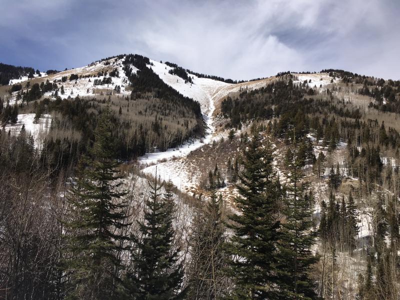
Horse Head Mountain and the view west from North Creek Pass. |
| type | aspect/elevation | characteristics |
|---|

|
|
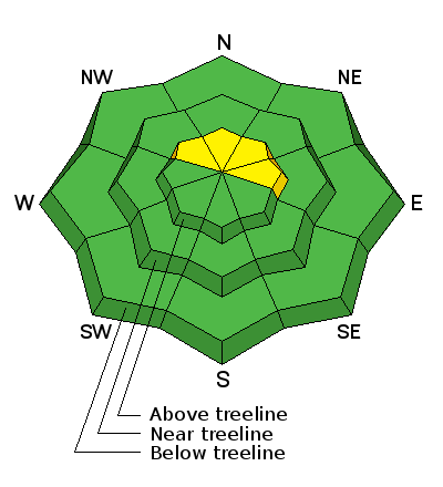
LIKELIHOOD
 LIKELY
UNLIKELY
SIZE
 LARGE
SMALL
TREND
 INCREASING DANGER
SAME
DECREASING DANGER
|
|
description
Low danger doesn't mean no danger and backcountry travelers still need to maintain a standard level of avalanche awareness. -Suspect steep, wind drifted slopes that have a smooth rounded appearance or that have a hollow sound or feel to them -Continue to avoid areas of steep, rocky, or radical terrain right around treeline and above that faces NW-N-E where it still may be possible to trigger an avalanche 2-3' deep on weak, sugary, faceted snow near the ground. -With daytime heating, avoid steep slopes with sloppy wet snow. -Ride slopes one at a time and stay out from underneath run out zones when someone else is on the slope. |
 |
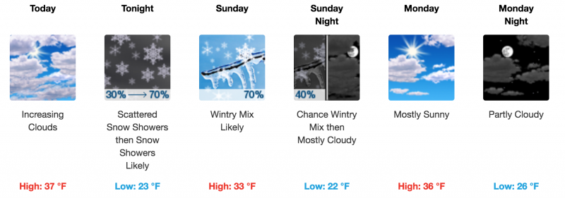
weather A weak cold front will slide through the area tonight and tomorrow bringing clouds, cooler air, and a slight chance for snow. Today expect partly sunny skies, mostly light WNW winds, and high temps at 10,000' in the upper 30's.
|
| general announcements The UAC has new support programs with Outdoor Research and Darn Tough. Support the UAC through your daily shopping. When you shop at Smith's, or online at Outdoor Research, REI, Backcountry.com, Darn Tough, Patagonia, NRS, Amazon, eBay a portion of your purchase will be donated to the FUAC. See our Donate Page for more details on how you can support the UAC when you shop. Benefit the Utah Avalanche Center when you buy or sell on eBay - set the Utah Avalanche Center as a favorite non-profit in your eBay account here and click on eBay gives when you buy or sell. You can choose to have your seller fees donated to the UAC, which doesn't cost you a penny This information does not apply to developed ski areas or highways where avalanche control is normally done. This advisory is from the U.S.D.A. Forest Service, which is solely responsible for its content. This advisory describes general avalanche conditions and local variations always occur. |