25th Annual Black Diamond Fall Fundraising Party
Thursday, September 13; 6:00-10:00 PM; Black Diamond Parking Lot
25th Annual Black Diamond Fall Fundraising Party
Thursday, September 13; 6:00-10:00 PM; Black Diamond Parking Lot
| Advisory: Abajo Area Mountains | Issued by Eric Trenbeath for Saturday - April 1, 2017 - 7:28am |
|---|

|
bottom line There is an isolated or MODERATE danger for triggering a shallow wind slab in steep, upper elevation terrain that faces W-N-E. If the sun pokes out we may see a few point release, wet sluffs out of rocky areas. Elsewhere the danger is generally LOW.
|
 |
special announcement The Abajo/Blue Mountain avalanche advisory will provide detailed information on the weekends. During the week, general information and a danger rating will be posted. |
 |
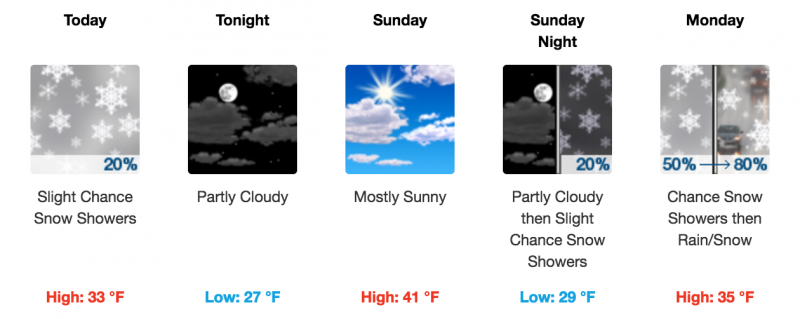
current conditions The mountains picked up 3-5" over the past 24 hours. Winds are light, and 10,000' temps are in the high 20's. |
 |
weather Residual clouds will hang over the mountains today with a few isolated flurries possible. ESE winds will average 10-15 mph shifting to northerly by this afternoon. High temperatures at 10,000' will be in the low 30's.
|
| general announcements If you are getting out into the mountains, we love to hear from you! You can SUBMIT OBSERVATIONS ONLINE If you would like to have avalanche advisories emailed to you, SIGN UP HERE Benefit the Utah Avalanche Center when you shop from Backcountry.com or REI: Click this link for Backcountry.com or this link to REI, shop, and they will donate a percent of your purchase price to the UAC. Both offer free shipping (with some conditions) so this costs you nothing! Benefit the Utah Avalanche Center when you buy or sell on ebayIf you sign up for AmazonSmile and designate the Utah Avalanche Center as your favorite charity, they will donate a portion of everything you spend to the UAC. I doesn't cost you a penny and we'd really appreciate the help. The information in this advisory is from the US Forest Service which is solely responsible for its content. This advisory describes general avalanche conditions and local variations always occur. |