25th Annual Black Diamond Fall Fundraising Party
Thursday, September 13; 6:00-10:00 PM; Black Diamond Parking Lot

25th Annual Black Diamond Fall Fundraising Party
Thursday, September 13; 6:00-10:00 PM; Black Diamond Parking Lot
| Advisory: Abajo Area Mountains | Issued by Eric Trenbeath for Sunday - March 19, 2017 - 6:47am |
|---|
 |
special announcement The Abajo/Blue Mountain avalanche advisory will provide detailed information on the weekends. During the week, general information and a danger rating will be posted. |
 |
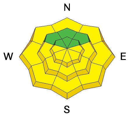
current conditions Skies are clear and SW winds are in the 10-15 mph range along ridge tops. It's 34 degrees on Abajo Peak and 41 at Camp Jackson. Spring time conditions are in effect. Supportable corn snow can be found in the mornings on SE-S-W aspects, though many of these areas are showing exposed ground. North facing aspects are either transitional, or wind affected dry snow. I've seen very little wet avalanche activity through the warm spell of the past 10 days, and the snowpack is mostly stable. Nevertheless, it is good practice to be out of avalanche terrain by about noon under these conditions - earlier on slopes with an easterly component, and slightly later on those that face west - or if you feel the snow becoming sloppy, wet, or punchy. |
| type | aspect/elevation | characteristics |
|---|


|


|

LIKELIHOOD
 LIKELY
UNLIKELY
SIZE
 LARGE
SMALL
TREND
 INCREASING DANGER
SAME
DECREASING DANGER
|
|
description
With daytime heating, the danger for loose, wet slide activity will increase. Be alert to signs of instability such as roller balls, pinwheels, or sloppy wet snow up around their boot tops. Follow the sun and get off of exposed aspects if any of these signs are present. Start early and end early, and as a general rule, plan to be out of avalanche terrain by around noon. |
 |
weather Today look for another sunny warm day with high temperatures at 10,000' to be around 50 degrees. SW winds will blow in the 15-20 mph range. Tonight we'll see a few clouds move in ahead of the first in a series of Pacific storm systems that will affect the area this week. We'll see a chance of showers developing on Monday, with our best chance for snow Wed-Fri. |
| general announcements If you are getting out into the mountains, we love to hear from you! You can SUBMIT OBSERVATIONS ONLINE If you would like to have avalanche advisories emailed to you, SIGN UP HERE Benefit the Utah Avalanche Center when you shop from Backcountry.com or REI: Click this link for Backcountry.com or this link to REI, shop, and they will donate a percent of your purchase price to the UAC. Both offer free shipping (with some conditions) so this costs you nothing! Benefit the Utah Avalanche Center when you buy or sell on ebayIf you sign up for AmazonSmile and designate the Utah Avalanche Center as your favorite charity, they will donate a portion of everything you spend to the UAC. I doesn't cost you a penny and we'd really appreciate the help. The information in this advisory is from the US Forest Service which is solely responsible for its content. This advisory describes general avalanche conditions and local variations always occur. |