25th Annual Black Diamond Fall Fundraising Party
Thursday, September 13; 6:00-10:00 PM; Black Diamond Parking Lot
25th Annual Black Diamond Fall Fundraising Party
Thursday, September 13; 6:00-10:00 PM; Black Diamond Parking Lot
| Advisory: Abajo Area Mountains | Issued by Eric Trenbeath for Sunday - January 29, 2017 - 7:37am |
|---|

|
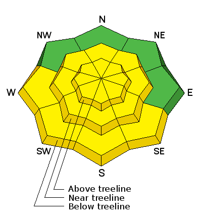
bottom line Today there is a MODERATE avalanche danger for triggering wind slabs old and new on all aspects in steep, upper elevation, wind exposed terrain. There is also an isolated MODERATE danger for triggering a deeper, persistent slab avalanche on slopes steeper than 35 degrees, at mid and upper elevations on slopes facing NW-E-SE. And finally, with daytime heating, a MODERATE danger exists for loose, wet slide activity on sun exposed slopes.
|
 |
special announcement The Abajo/Blue Mountain avalanche advisory will provide detailed information on the weekends. During the week, general information and a danger rating will be posted. Backcountry 101 Avalanche Class We will be offering a Backcountry 101 avalanche class on Feb 3, 4. This course will include a night classroom session and a day in the field. Cost is $125 with proceeds to benefit the Utah Avalanche Center Moab. For more information or to sign up go here. |
 |
current conditions Skies are clear this morning and contrary to the rest of the region, winds are light to moderate from the southwest. It's 26 degrees at 9000' and 13 on Abajo Peak. Soft settled powder can still be found in sheltered locations, but southerly aspects may have a thin crust on them this morning. Overall snow depth now ranges from 2-4' across the range. |
 |
recent activity Dustin Randall reported a very large avalanche off of Horse Head Mountain that ran during the storm cycle of last weekend. According to his report, it was up to 1500' wide, taking out the whole bowl and running most of the track. |
| type | aspect/elevation | characteristics |
|---|

|
|
LIKELIHOOD
 LIKELY
UNLIKELY
SIZE
 LARGE
SMALL
TREND
 INCREASING DANGER
SAME
DECREASING DANGER
|
|
description
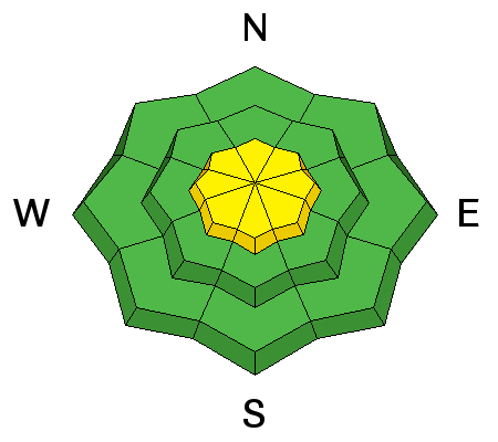
Wind slabs old and new continue to be the primary concern. Northeast winds have deposited shallow wind drifts on southerly aspects, primarily in upper elevation terrain. Mostly shallow and manageable, they'll be a bit more stubborn today, but be alert to areas of wind drifted snow on the lee sides of ridge crests and terrain features, and look for areas of cross loading on the sides of gully walls and sub-ridges. It may also still be possible to trigger an older, deeper wind slab that formed during the storm cycle of last weekend. Very strong, southwest winds on Monday deposited vast amounts of snow on to leeward, northerly aspects. Most of these slabs are pretty well stuck in place, but there could be an isolated fat pocket here in there that could break out and take you for an ugly ride. Pay attention to smooth rounded pillows of snow, especially if they sound hollow like a drum, and avoid wind loaded slopes with steep convexities. |
| type | aspect/elevation | characteristics |
|---|

|
|
LIKELIHOOD
LIKELY
UNLIKELY
SIZE
 LARGE
SMALL
TREND
INCREASING DANGER
SAME
DECREASING DANGER
|
|
description
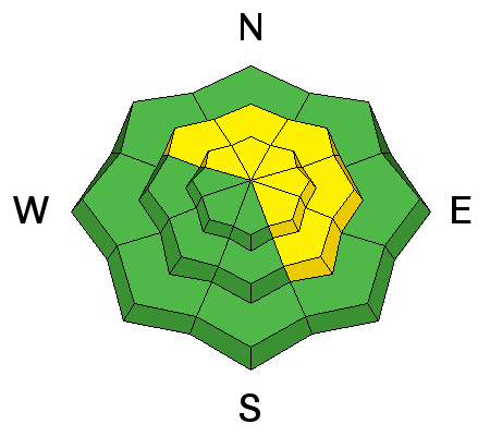
Heavy snowfall and wind loading last weekend increased the stress on buried weak layers and several slides broke down into older snow. The snowpack has begun to adjust to this new load, but steep terrain should still be approached with caution. Upper-mid elevation, northerly facing aspects are the most suspect, particularly in areas of steep, rocky, heavily featured terrain. |
| type | aspect/elevation | characteristics |
|---|

|
|
LIKELIHOOD
 LIKELY
UNLIKELY
SIZE
 LARGE
SMALL
TREND
 INCREASING DANGER
SAME
DECREASING DANGER
|
|
description
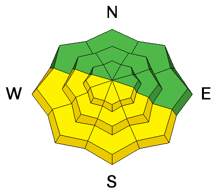
With daytime heating we may see some loose, wet slide activity on sun exposed slopes. I don't see these packing much of a punch, but it's good to be aware of signs of instability such as roller balls, and sloppy wet snow, and good practice to stay off of steep slopes when these signs are present. |
 |
weather High pressure is building over the region and temperatures should gradually warm over the next few days. The long range shows a hint at precipitation by late next week. Today Sunny, with a high near 29. North wind 10 to 15 mph, with gusts as high as 25 mph. Tonight Mostly clear, with a low around 17. North northwest wind around 10 mph. Monday Sunny, with a high near 32. West northwest wind 5 to 10 mph. Monday Night Mostly clear, with a low around 20. West wind around 10 mph. Tuesday Sunny, with a high near 32. West southwest wind around 10 mph. Tuesday Night Mostly clear, with a low around 22. Wednesday Mostly sunny, with a high near 33. Wednesday Night Partly cloudy, with a low around 23. Thursday Mostly sunny, with a high near 35. Thursday Night Mostly cloudy, with a low around 25. Friday Partly sunny, with a high near 34. |
| general announcements If you are getting out into the mountains, we love to hear from you! You can SUBMIT OBSERVATIONS ONLINE If you would like to have avalanche advisories emailed to you, SIGN UP HERE Benefit the Utah Avalanche Center when you shop from Backcountry.com or REI: Click this link for Backcountry.com or this link to REI, shop, and they will donate a percent of your purchase price to the UAC. Both offer free shipping (with some conditions) so this costs you nothing! Benefit the Utah Avalanche Center when you buy or sell on ebayIf you sign up for AmazonSmile and designate the Utah Avalanche Center as your favorite charity, they will donate a portion of everything you spend to the UAC. I doesn't cost you a penny and we'd really appreciate the help. The information in this advisory is from the US Forest Service which is solely responsible for its content. This advisory describes general avalanche conditions and local variations always occur. |


