25th Annual Black Diamond Fall Fundraising Party
Thursday, September 13; 6:00-10:00 PM; Black Diamond Parking Lot
25th Annual Black Diamond Fall Fundraising Party
Thursday, September 13; 6:00-10:00 PM; Black Diamond Parking Lot
| Advisory: Abajo Area Mountains | Issued by Eric Trenbeath for Saturday - January 14, 2017 - 7:25am |
|---|


|
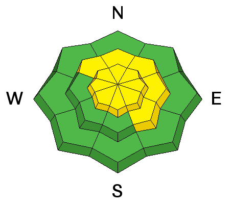
bottom line The avalanche danger is MODERATE today on steep, upper elevation slopes that have recent deposits of wind drifted snow. Be alert to changing conditions and signs of increasing instability such as cracking in the snow surface. The danger could rise to CONSIDERABLE if high end, forecasted snow totals pan out. Watch for fresh drifting on the lee sides of ridge crests and terrain features, and avoid steep slopes that have smooth rounded deposits of wind drifted snow. Out of the wind zone at mid and lower elevations the danger is mostly LOW.
|
 |
special announcement The Abajo/Blue Mountain avalanche advisory will provide detailed information on the weekends. During the week, general information and a danager rating will be posted. |
 |
current conditions 4-8" of new snow fell in the Abajo/Blue Mountains Thursday night into Friday and it's finally starting to look like winter up there. In my travels yesterday I found plenty of new soft snow to scoot around in, and coverage is significantly improved. Wind exposed slopes are still showing some grass, but leeward and sheltered slopes are filling in quite nicely and snow depths now range from 2-3' at mid and upper elevations. For real time weather data click on the links below: Winds, temperature and humidity on Abajo Peak. Snow totals at Camp Jackson. |
| type | aspect/elevation | characteristics |
|---|

|
|
LIKELIHOOD
 LIKELY
UNLIKELY
SIZE
 LARGE
SMALL
TREND
 INCREASING DANGER
SAME
DECREASING DANGER
|
|
description
Winds yesterday were blowing a fair amount of snow around forming new, shallow wind slabs on the lee sides of ridge crests and terrain features, primarily in upper elevation, wind exposed terrain. These new, soft slabs are also covering up harder slab that have formed as a result of the strong southwest winds of the past week. Avoid steep slopes that have smooth, rounded, drifted appearance, and look for signs of instability such as cracking in the snow surface. |
| type | aspect/elevation | characteristics |
|---|

|
|
LIKELIHOOD
LIKELY
UNLIKELY
SIZE
LARGE
SMALL
TREND
INCREASING DANGER
SAME
DECREASING DANGER
|
|
description
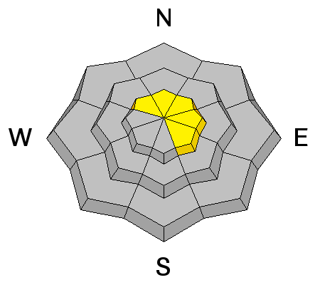
The underlying snow pack is very weak with loose, sugary faceted snow at the ground. We are starting to develop a load over top of this weak foundation, and a triggered, over riding wind slab has the potential to break down to this buried weak layer causing a deeper and more dangerous avalanche. Areas where you are most likely to find this problem are on steep, upper elevation slopes that face the north half of the compass. |
 |
weather A band of moisture tracking through the 4 Corners may produce snow for us later today and through tonight with up to 6" of new snow by tomorrow. Southwest winds will blow in the 10-15 mph range with gusts into the 20's. High temperatures at 10,000' will be near 30 degrees. |


