25th Annual Black Diamond Fall Fundraising Party
Thursday, September 13; 6:00-10:00 PM; Black Diamond Parking Lot
25th Annual Black Diamond Fall Fundraising Party
Thursday, September 13; 6:00-10:00 PM; Black Diamond Parking Lot
| Advisory: Abajo Area Mountains | Issued by Eric Trenbeath for Monday - December 26, 2016 - 5:32am |
|---|

|
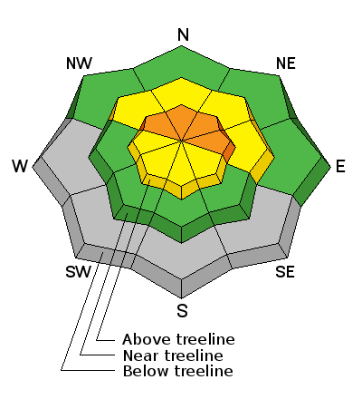
bottom line The avalanche danger remains CONSIDERABLE today in steep, upper elevation terrain where blustery winds and blowing snow have created fresh drifts and newly formed wind slabs. On slopes that face NW-N-E, a triggered wind slab also has the potential to step down causing a deeper and more dangerous persistent slab avalanche. The danger is MODERATE at mid elevations. For LOW danger stick to the lower elevations.
|
 |
special announcement |
 |
current conditions The Abajo Mountains have picked up about a foot of snow since Friday, and base depth at Camp Jackson is 22". Overall, It's still pretty thin coverage with a lot of grass and bushes poking out, but things are improving. WNW winds blew in the 20-30 mph range on Saturday, but have been remarkably light over the past 24 hours. It's currently -1 degree on Abajo Peak and 11 at Camp Jackson. Winds, temperature and humidity on Abajo Peak. Snow totals at Camp Jackson. |
| type | aspect/elevation | characteristics |
|---|

|
|
LIKELIHOOD
 LIKELY
UNLIKELY
SIZE
 LARGE
SMALL
TREND
 INCREASING DANGER
SAME
DECREASING DANGER
|
|
description
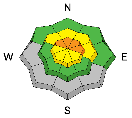
Moderate to strong, gusty winds with plenty of loose snow available for transport over the weekend translated to drifting snow and the formation of new wind slabs. Avoid areas of recently deposited, wind drifted snow and look for tell tale signs of instability such as cracking in the snow surface. A triggered wind slab also has the potential to step down into a deeper persistent slab. |
| type | aspect/elevation | characteristics |
|---|

|
|
LIKELIHOOD
LIKELY
UNLIKELY
SIZE
LARGE
SMALL
TREND
 INCREASING DANGER
SAME
DECREASING DANGER
|
|
description
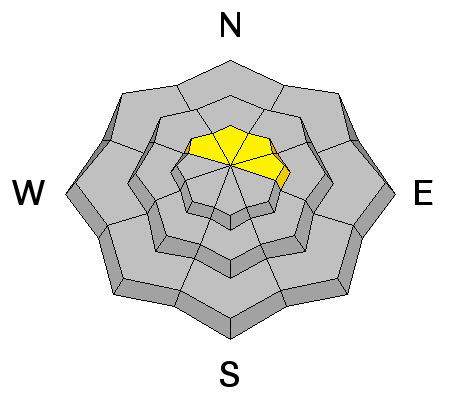
The underlying snowpack is very weak, and additional snow load from overriding wind slabs has increased the danger for trigger a deeper persistent slab avalanche. You are most likely to find this problem on steep, upper elevation slopes that have a NW-N-E aspect. |
 |
weather Today Sunny, with a high near 20. Wind chill values as low as -10. West wind 5 to 15 mph. Tonight Mostly clear, with a low around 14. West wind around 10 mph, with gusts as high as 20 mph. Tuesday Sunny, with a high near 30. Southwest wind 10 to 15 mph. Tuesday Night Mostly clear, with a low around 20. West southwest wind around 15 mph. Wednesday Sunny, with a high near 32. West wind 10 to 15 mph becoming north northwest in the afternoon. Wednesday Night Mostly clear, with a low around 18. Thursday Sunny, with a high near 31. Thursday Night Mostly clear, with a low around 22. Friday A chance of snow, mainly after 11am. Partly sunny, with a high near 31. |


