Observation Date
3/22/2014
Observer Name
Ted Scroggin
Region
Uintas » Bear River Ranger District » Whitney Basin
Location Name or Route
Whitney Basin
Weather
Sky
Scattered
Wind Direction
West
Wind Speed
Light
Weather Comments
It was 10-15 degrees warmer this morning at the trail head than yesterday's single digit start. A cloudy morning gave way to a nice afternoon with scattered clouds, slightly cool temperatures which prevented any wet activity and preserved some nice cold powder snow on high north facing slopes.
Snow Characteristics
New Snow Depth
2"
New Snow Density
Medium
Snow Surface Conditions
Powder
Wind Crust
Melt-Freeze Crust
Snow Characteristics Comments
It's that time of year where you can travel just about anywhere on a nice supportable base. Just a trace of new snow at the trail head this morning, but was surprised to find a couple of inches in Whitney Basin. There was nice cold powder snow on the high north facing slopes and south facing areas had a fun dust on crust condition.
Red Flags
Red Flags Comments
I did not encounter any red flag conditions in my travels around the Whitney Basin. There was likely a few soft wind slabs that a person might stumble into if riding along the high ridgelines, but things seemed pretty manageable.
Avalanche Problem #1
Problem
Persistent Weak Layer
Trend
Decreasing Danger
Problem #1 Comments
Not a real threat today, but the Uintas always seem to have enough wind somewhere to blow any available snow around. I was finding little snow moving around on high ridgelines and the wind drifts I stomped on were pretty relaxed.
Avalanche Problem #2
Problem
Persistent Weak Layer
Trend
Same
Problem #2 Comments
The north slope has really filled-in with our last few storms and the snow pack is quite deep in places I dug. I was finding almost 90" of total snow depth on the ground in higher elevations around the Whitney area. But this is not where a person could trigger a deep slab avalanche. Where the snow pack remains thin and connected to deeper part of the slope is likely where a deeper slab avalanche could be triggered.
Comments
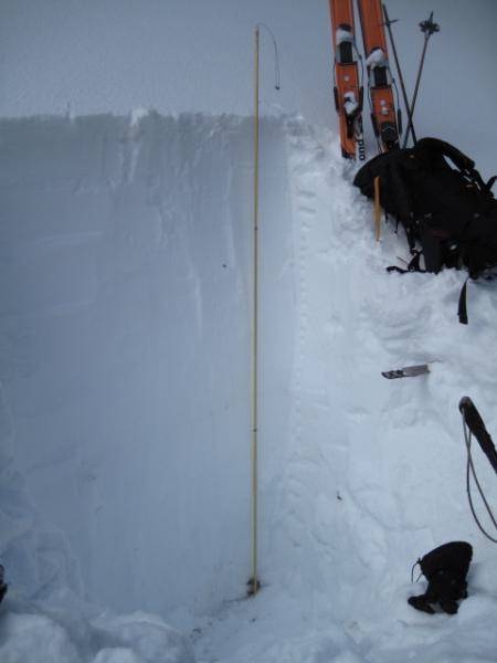
A somewhat representative area of the snow pack in the higher elevations of the Whitney Basin. Almost 90" of snow with densities increasing as you go down the snow pack. There is still weak faceted snow near the ground, but it has gained some strength over time and is not nearly as well developed as early in the season.
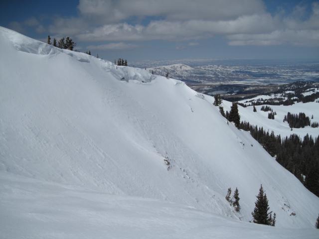
On this slope the thin snow cover around the bushes is a likely spot where we could trigger an avalanche.
Today's Observed Danger Rating
Moderate
Tomorrows Estimated Danger Rating
Moderate