Observation: Emma Ridges

Observation Date
1/2/2026
Observer Name
Fullmer
Region
Salt Lake » Little Cottonwood Canyon » Emma Ridges
Location Name or Route
West Bowl
Weather
Sky
Obscured
Precipitation
Light Snowfall
Wind Direction
Northwest
Wind Speed
Light
Weather Comments
Warm, hovering around freezing at mid-upper elevations, but at least it felt like winter!
Snow Characteristics
New Snow Depth
13"
New Snow Density
High
Snow Surface Conditions
Powder
Snow Characteristics Comments

Heavy new snow! But I welcome that and it has helped fill in a lot of the upper elevation terrain. Below 35* slope angle, I wasn't scrapping the CERC. In steeper terrain, I had some minimal scraping. With settlement that probably won't be an issue. Turns were creamy and slow today.

About 33cm (13") of new, very dense, snow. The new snow is settling (compacting) quickly.

Red Flags
Red Flags
Recent Avalanches
Poor Snowpack Structure
Red Flags Comments
No cracking or collapsing, but with some wind this dense snow will quickly form into wind slabs. I'm sure there was cracking, collapsing, and wind slabs today at the right locations, but none where I traveled. The "recent avalanche" was the reported observation today on Jaws. I traveled past it, but didn't see it, but did see the UAC Instragram story.
Avalanche Problem #1
Problem
Persistent Weak Layer
Trend
Same
Problem #1 Comments

Is there a new weak layer developing on top of the CERC (Christmas Eve Rain crust), or is it storm snow instability at the moment? On top of the crust I found 5cms of graupel and faceting that occurred between December 28 and January 2. The snow was not cohesive. Snow assessment results below. Beneath the CERC in my travels, at 10,130' on a NW aspect, the bottom layer of facets were 25cms deep to the ground. They were still damp and easy to squeeze into a snowball. This was in near a ridgeline in sparse woods, where the snowpack is visible to sunlight on a clear day, i.e. this isn't necessarily representative of a NW sheltered aspect at the same elevation.

Avalanche Problem #2
Problem
Wind Drifted Snow
Problem #2 Comments

No signs of wind slabs in my travels as I avoided these areas and the low visibility in the early morning hours prevented spotting wind slabs or wind transport. With some wind, I would be concerned about the dense new snow forming a dense slab on top of a weak graupel layer that then sits on a slick rain crust. These could be medium sized and consequential wind slabs, possibly being enough of a load to collapse the CERC and early season facets, creating a more consequential avalanche.

Comments

Travel was a quick one, from Alta to West Bowl via Emma's, a couple of laps in West Bowl, then exit.

Height of snow:

  • 9800' SW aspect: 30cm (1 foot) of snow on the CERC
  • At the base of West Bowl (9500') the snow was 95cm (3.10 feet) deep. 45cm (18") on the CERC.
  • 10,130' on NW aspect: the snow was 75cm (29.5") deep, with 40cm (16") on top of a 10cm (4") CERC. The bottom 25cm (10") were the damp early season facets.

At the last location (10,130' NW aspect) I had the following results:

  • CT11 SC down 35cm within the 5cms of weak snow and graupel above the CERC.
  • ECTN13 at the new/old snow interface (down 30cm) and a ECTN21 within the early season facets beneath the CERC

While I did not get propagation in my singular ECT within the weak snow/graupel on top of the CERC, I am still interested to see what happens with that layer when we receive more of a load.

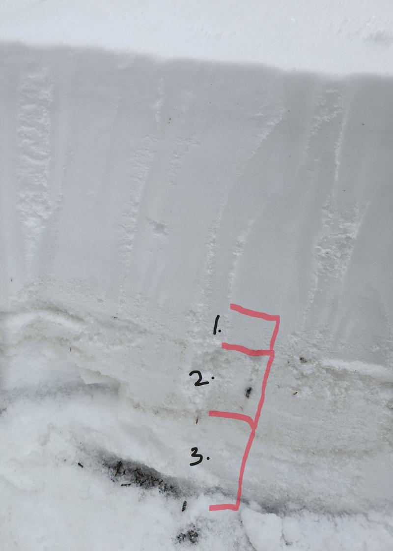
In photo: (labels are as follows)

1. I am going to keep an eye on this layer. Will it settle or develop as a weak layer? These 5cms of snow are not only graupel, but faceting occurred from Dec. 28-Jan. 1. This was what I assessed in just one location, but I didn't look a lot of places today. Interested to read what the rest of the community observed.

2. A 10cm (4") rain crust. Seemed really stout at 10,130' on NW aspect, but this was NOT steep and rocky terrain.

3. Roughly 25cms (10") of damp early season facets.

Video
Today's Observed Danger Rating
Considerable
Coordinates