Donate Now to Our Year End Campaign!

Observation: Alta Periphery

Observation Date
12/30/2025
Observer Name
Gagne
Region
Salt Lake » Little Cottonwood Canyon » Alta Periphery
Location Name or Route
Upper LCC
Weather
Sky
Clear
Wind Direction
Northwest
Wind Speed
Light
Weather Comments
Light winds from the northwest with no drifting.
Snow Characteristics
Snow Surface Conditions
Dense Loose
Damp
Snow Characteristics Comments

Snow depths above 9,000 feet range from 60-100 cms (2-3+ feet) and the Friday/Saturday storm snow has settled out to 30 cms (12 inches), although thinner in areas that were wind-scoured or thicker in areas that were wind-drifted.

A few pockets of shallow wind drifts that were unreactive.

The snow surface has weakened slightly (near-surface faceting), but it is not especially weak.

I also found evidence of radiation recrystallization (RR) on some sunny slopes where the top ~5 mm of the snow surface has turned to facets, with a crust underneath - photo below. This link will bring you to an AI description of the process - for those that are curious, it's a worthy quick read.

Given warming temperatures on Wednesday and a warm storm forecast for Thursday, it is unlikely any weaknesses near the existing snow surface will remain intact before we add more snow.

A small, wet-loose avalanche on the south face of Wolverine

Red Flags
Red Flags
Poor Snowpack Structure
Red Flags Comments
More on the snowpack structure below.
Avalanche Problem #1
Problem
Persistent Weak Layer
Trend
Same
Problem #1 Comments

The PWL remains an issue above about 9,000 feet, but the Christmas Rain Crust is strong and supportable on most slopes, and it is less likely you can trigger an avalanche that fails on the buried PWL. Steep slopes at the upper elevations are most suspect where the crust is likely to be thinner, there is a stronger slab above the crust from more snow and wind-drifted snow, and the PWL is dry and weak.

The photo below is from the starting zone of Sunday's avalanche on Sunset Peak which seems to meet the criteria I've listed above.

Comments

Travel today was out of Alta: Catherine's Pass -> Sunset Peak -> Wolverine Bowl -> Grizzly Gulch. Elevations covered were 9,000 - 10,800 feet.

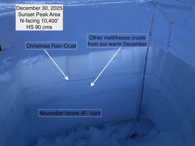
I was focusing on the Christmas Rain Crust: its thickness and any faceting that may be occurring around the crust (rain crusts are notorious for developing facets both above and below the crust.) The good news is that the crust is stout and strong - generally 2-4 cms thick (1-2 inches) with no faceting, yet. In some places, the crust is up to 10 cms (4 inches) thick. The one slope I found the thinner crust was adjacent to Sunday's Sunset Peak avalanche where the crust was only 2-3 mm thick in places, with dry/loose facets and depth hoar down to the ground. From what I observed, the rider seemed to hit the sweet spot on the slope.

The photo below is from the slope adjacent to the Sunset Peak avalanche and it shows the complex structure of our current snowpack:

All stability tests today (extended column and compression) showed a stable snowpack where the crust was strong enough to support a load.

Today's Observed Danger Rating
None
Tomorrows Estimated Danger Rating
None
Coordinates