Donate Now to Our Year End Campaign!

Observation: Twin Lakes Pass

Observation Date
12/17/2025
Observer Name
Colin Gregersen
Region
Salt Lake » Little Cottonwood Canyon » Grizzly Gulch » Twin Lakes Pass
Location Name or Route
Twin Lakes Pass
Weather
Sky
Overcast
Precipitation
Heavy Snowfall
Wind Direction
West
Wind Speed
Strong
Weather Comments
Strong westerly winds accompanied a brief, but intense storm that began around 1:30 pm. Gusts were strong enough at times to knock me off balance. I experienced two, scary flashes of lightning with thunder shortly following. Temps were warm overall, though strong winds and heavy precipitation made it feel colder.
Snow Characteristics
New Snow Depth
4"
New Snow Density
High
Red Flags
Red Flags
Heavy Snowfall
Wind Loading
Poor Snowpack Structure
Red Flags Comments
Wind transport appeared limited to the new storm snow. Storm snow was dense — I was able to easily form snowballs from it. It was setting up quickly and made for surfy turns. In steep terrain, graupel was running freely over exposed rock bands above the Highway to Heaven Traverse (see video) and pooling at the bottom of the cliffs. Short term, I’ll be paying close attention to locations where graupel may have pooled and may overload the underlying weak snowpack. While wind loading was front-of-mind, I did not see much transport onto lee slopes at the pass.
Avalanche Problem #1
Problem
Wind Drifted Snow
Problem #1 Comments

I did not observe much wind slab formation in the terrain I traveled, likely due to the sheltering effect of trees along the west face of the pass. In more exposed, upper-elevation terrain, I would expect the potential for sensitive wind slabs given the faceted, weak old snow surface underlying the new snow.

Avalanche Problem #2
Problem
Persistent Weak Layer
Problem #2 Comments

I didn't observe any cracking or collapsing today. Not sure if the new water weight is enough to tip the scales?

Comments

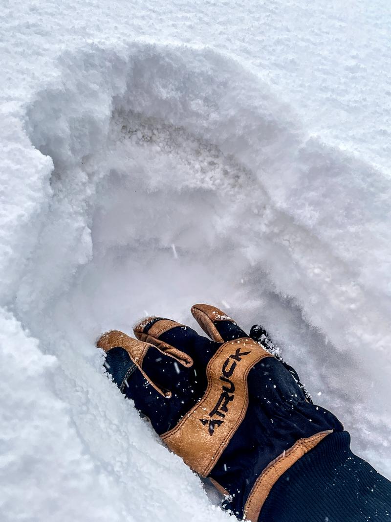
Travel was from Alta to Twin Lakes Pass. Aspects skied were N and E facing with slope angles up to about 33 degrees. Moderate to heavy graupel began around 1:30 pm and continued through my exit at approximately 4:15 pm. Estimated precipitation rates were around 1 inch per hour, with roughly 3–3.5 inches of new snow by the end of the tour. Precipitation initially fell as large graupel pellets, painful on bare skin. This phase left a distinct, discolored layer approximately 1 inch thick within the storm snow (see photo).

Snowfall appeared highly elevation dependent. While precipitation was impressive at the elevations I traveled (10,000 ft), snow amounts tapered off quickly as I drove down LCC. Below Snowbird and past the White Pine trailhead, I only observed light sleet with little to no accumulation along the roadway.

Video
Today's Observed Danger Rating
Moderate
Coordinates