Check Out Our Holiday Auction!

Observation: Guardsman Pass area

Observation Date
12/9/2025
Observer Name
Hardesty
Region
Salt Lake » Big Cottonwood Canyon » Guardsman Pass area
Location Name or Route
Guardsman Pass
Weather
Sky
Overcast
Wind Direction
Northwest
Wind Speed
Moderate
Weather Comments
Warm and windy. Overcast. The Brighton snotel site just around the corner at elevation 8765' had a daytime high of 39*F. https://www.weather.gov/wrh/timeseries?site=BRIU1&hourly=true - Despite moderate to strong winds, I didn't note any blowing and drifting snow.
Snow Characteristics
New Snow Density
High
Snow Surface Conditions
Damp
Snow Characteristics Comments

Damp, thick, supportable, and surfy on all aspects; surface snow on the northerly aspects are damp at least to 9700'. One can make a snowball with this surface snow and I suspect that any recently developed sharp edges on the surface (faceting) have started to round off. Plenty of time to swing the other way, though.

Southerly aspects are patchy and brown...and will only become more patchy and brown with the forecast very warm temperatures and no reliable storms on the horizon....

Red Flags
Red Flags
Poor Snowpack Structure
Red Flags Comments
Only noted poor structure today. I didn't experience any cracking or collapsing.
Avalanche Problem #1
Problem
Persistent Weak Layer
Trend
Same
Problem #1 Comments

Poor structure with ECTN 19&21 and ECTP21 and a GROM Score of 4 at my snow pit at 9700'. Photos below tell the tale.

Avalanche Problem #2
Problem
Wind Drifted Snow
Trend
Decreasing Danger
Problem #2 Comments

Although the northwest winds have been relentless, I imagine (time and warm temps) most of these soft and hard slabs of wind drifted snow have become stubborn and difficult to trigger. Cornice lip and wind drifts on the southeast face of Tri-County Peak.

Snow Profile
Aspect
Northeast
Elevation
9,700'
Comments

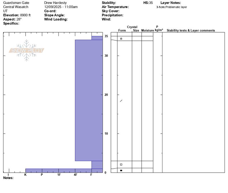
Faceted grains noted down as low as 8900' on a northerly facing aspect. These facets sit uncomfortably over a hard basal melt freeze crust. Note second profile.

Today's Observed Danger Rating
Moderate
Tomorrows Estimated Danger Rating
Moderate
Coordinates