Check Out Our Holiday Auction!

Observation: Davenport Hill

Observation Date
12/7/2025
Observer Name
Champion, Collett, Talty
Region
Salt Lake » Little Cottonwood Canyon » Davenport Hill
Location Name or Route
Davenport Hill
Weather
Sky
Scattered
Wind Speed
Calm
Weather Comments
Following the storm, it was a break in the weather and a good day for a walk. Skies were broken throughout the day with scattered clouds and brief bursts of sun in the morning, then filling back in by late afternoon. Temperatures stayed in the low 20s and upper teens, and winds were mostly light with some moderate gusts along the ridgelines. Signs of the stronger winds from earlier were obvious.
Snow Characteristics
New Snow Depth
16"
New Snow Density
Medium
Snow Surface Conditions
Powder
Wind Crust
Snow Characteristics Comments

Between 1 and 2 feet of new medium to high-density storm snow was pretty evenly distributed in upper Little Cottonwood. While it was noted elsewhere, we did not see any obvious signs of surface hoar where we traveled. The main takeaway was the widespread wind texture across many upper elevation slopes. Some areas showed strong texture, while others, mainly on northerly aspects that were not protected, also had wind effect. This included sub ridges and funnel like features.

Textured snow surface - 9500' - SW Aspect

Scoured East Bowl - 9900' - NW Aspect

Additional surface texture - 9700' - SW Aspect

Red Flags
Red Flags
Recent Avalanches
Wind Loading
Cracking
Collapsing
Poor Snowpack Structure
Avalanche Problem #1
Problem
Persistent Weak Layer
Trend
Same
Problem #1 Comments

Peak instability seemed to occur yesterday, but the snowpack structure is still weak. We continued to see large cracks and collapses while walking around, especially on the north side of the compass. We traveled between East Bowl Pass, where we found both a very weak and scoured snowpack, and then moved along the ridgeline toward Davenport to look at the avalanche Trent and Brooke remotely triggered yesterday. We found a 4F to 1F slab sitting on 30 cm of weak, well developed facets.

Looking ahead, the signs of instability may become less obvious, with fewer cracks and collapses, but the most suspect areas will be the ones that look best to ride. Much of the upper elevation north-facing terrain saw a lot of wind and is stripped along ridgelines, but a few hundred feet below ridgelines or in more protected terrain features, the poor structure still exists. The strong over weak setup remains and will continue to be an issue.

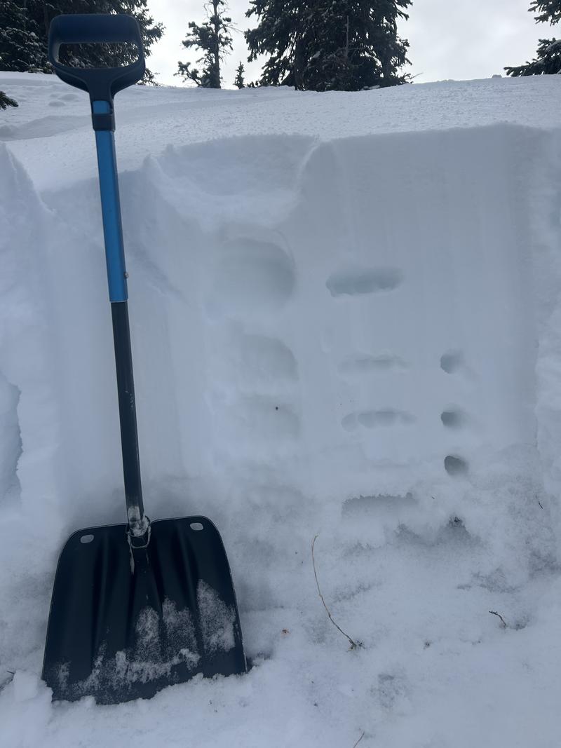
Avalanche crown profile - Davenport Hill - NE Aspect - 9900' - weak facets on the ground

Snow Profile
Aspect
Northeast
Elevation
9,900'
Slope Angle
36°
Video
Today's Observed Danger Rating
Considerable
Tomorrows Estimated Danger Rating
Considerable
Snow Pilot URL