Observation Date
12/7/2025
Observer Name
N Sievers / A Crow
Region
Salt Lake » Park City Ridgeline
Location Name or Route
PC Ridgeline
Weather
Sky
Broken
Wind Direction
West
Wind Speed
Moderate
Weather Comments
Clear skies in the early morning veered broken towards early afternoon with increasing stratus coverage. Overcast skies built up by late afternoon.
Snow Characteristics
New Snow Depth
12"
Snow Surface Conditions
Powder
Snow Characteristics Comments
4-6mm Surface Hoar was found present at nearly all elevations and aspects, likely forming overnight atop 2-3mm graupel. 20-40cm of new snow from the 12/5-12/6 storm was found along travels from Guardsman Pass northward. New snow was evenly distributed below and near treeline. Within exposed areas at and above treeline, effects from yesterday's W-NW winds were obvious - with windward aspects holding stripped rime-covered snow surfaces and leeward aspects boasting a much deeper snowpack. Based on observations yesterday and a solid period of clear skies overnight, new snow appeared to have lost it's initial consolidation within the upper 20cm of new snow. Residual moisture increased with depth within new snow, reaching moist at and above the old snow interface (buried November facets). In general, our new snow structure is still upside down, resting on a bed of nails.
Red Flags
Red Flags
Recent Avalanches
Wind Loading
Cracking
Collapsing
Poor Snowpack Structure
Red Flags Comments
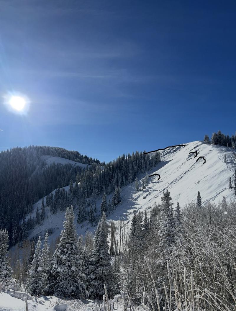
Travels today extended towards Main Mac and West Monitor from Guardmans Pass. Several SS-N-D1-O avalanches were observed, likely failing within the peak of the storm yesterday were found along the NW half of Guardmans Peak. Beyond this, feedback was less obvious compared to yesterday, with only a handful of shooting cracks and collapses found along steep cutbanks. Where it was reasonable to inspect our new snow along leeward aspects, slab qualities lacked strength (<4F), however, our snowpack structure is poor and likely more sensitive on connected pieces of terrain facing W-N-E above 9500ft. No need to poke that bear.
Avalanche Problem #1
Problem
Persistent Weak Layer
Trend
Same
Problem #1 Comments
Less feedback compared to yesterday, the only presumed natural cycle observed was noted just shy of Guardsman Peak. Peak reactivity seems to have settled down a bit, behaving stubborn where we traveled. Consequences where this old snow exists below our new 12/5-12/6 load are still very high, with runouts and tracks still holding very thin coverage.
Avalanche Problem #2
Problem
Wind Drifted Snow
Trend
Decreasing Danger
Problem #2 Comments
Wind loading from yesterday's wind was present along N-NE-E-SE aspects in exposed areas, primarily at and near ridgelines. No noted natural activity or continued loading was observed today.
Comments
x4 SS-N-D1-O observed on the backside of Scott's Back Door zone. Crowns outlined in black, debris and flank were recovered by recent westerly winds and snow transport. Far looker's left avalanche appeared to have wrapped around bowl with moderate energy, with trees occluding its total crown extent. Failures appeared to be pocketed, failing around rocky outcroppings. These could have been remotely triggered during the backcountry user's travels yesterday. Mostly small pockets, likely failing naturally or remotely within the past 24 hours.
Today's Observed Danger Rating
Considerable
Tomorrows Estimated Danger Rating
Considerable
Coordinates