Check out our Holiday Auction - Sign Up for the Utah Snow and Avalanche Workshop (USAW)

Observation: Monitors

Observation Date
11/27/2024
Observer Name
Hoffman, Jiricko
Region
Salt Lake » Park City Ridgeline » Monitors
Location Name or Route
Park City Ridgeline
Weather
Sky
Broken
Precipitation
Light Snowfall
Wind Direction
West
Wind Speed
Calm
Weather Comments
Sky ranged from few to obscured, trending towards clearing in late PM.
Snow Characteristics
New Snow Depth
14"
Snow Surface Conditions
Powder
Snow Characteristics Comments
New snow ranged from 12"-16". During our travels we noted minimal wind-affected snow besides isolated pockets along the PC ridgeline.
Red Flags
Red Flags
Heavy Snowfall
Collapsing
Poor Snowpack Structure
Red Flags Comments
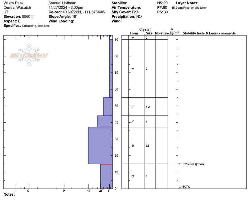
Collapsing on N-E aspects. Most we would describe as localized with one standout, widespread whumpf.
Avalanche Problem #1
Problem
Persistent Weak Layer
Problem #1 Comments
See attached profiles below.
Snow Profile
Aspect
Northwest
Elevation
9,600'
Slope Angle
25°
Comments
Our main observation today was the large variability in snowpack depth. On the North half of the compass, HS ranged from 40cm-140cm.
Today's Observed Danger Rating
None
Tomorrows Estimated Danger Rating
None
Coordinates