Observation Date
2/13/2024
Observer Name
Ted Scroggin
Region
Uintas
Location Name or Route
Whitney Basin
Weather
Sky
Few
Wind Direction
Southwest
Wind Speed
Moderate
Weather Comments
After a cool start to the day the temperatures warmed nicely with some high clouds till later in the afternoon when thicker clouds moved in. Southwest winds were a little brisk on the exposed ridge lines, but nice and calm elsewhere.
Snow Characteristics
Snow Surface Conditions
Dense Loose
Faceted Loose
Damp
Snow Characteristics Comments
Mostly really nice dense settled powder conditions with loose faceted snow on the surface from cold clear nights. I did find a little damp snow on the south facing slopes, but the winds kept things from getting too wet and damp.
Red Flags
Red Flags
Recent Avalanches
Wind Loading
Red Flags Comments
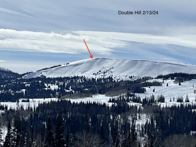
The south and southwest winds along the ridge lines were breezy, but I did not notice a lot of snow being blown around. I did spot a fresh natural wind slab on the east side of Double Hill where the south winds can get a bit strong and drift snow.
Avalanche Problem #1
Problem
Wind Drifted Snow
Trend
Increasing Danger
Problem #1 Comments
Maybe a fresh round of wind drifted snow this evening with a small storm moving in. There is plenty of loose snow on the surface to blow and create sensitive drifts on the leeward side.
Avalanche Problem #2
Problem
Persistent Weak Layer
Trend
Same
Problem #2 Comments
No recent avalanches that broke into the weak faceted layer buried in the snow pack.
Comments
Spotted this fresh wind slab today as I was leaving the Whitney area. My guess is the southwest winds were drifting the loose surface snow and a fresh cornice broke off and entrained snow as it moved down hill.
I went with a moderate hazard from my travels today which were in the core of the Whitney Basin.
Today's Observed Danger Rating
Moderate
Tomorrows Estimated Danger Rating
None
Coordinates