Observation: Gobblers

Observation Date
3/21/2023
Observer Name
Meisenheimer / Kelly
Region
Salt Lake » Big Cottonwood Canyon » Mill Creek Canyon » Mill A » Butler Fork » Gobblers
Location Name or Route
Butler Fork to Cabin Run to Alexander Basin
Weather
Sky
Scattered
Wind Speed
Calm
Weather Comments
Hot. We noted some green-housing even on the north-facing slopes today.
Snow Characteristics
New Snow Depth
10"
New Snow Density
Medium
Snow Surface Conditions
Powder
Wind Crust
Melt-Freeze Crust
Damp
Snow Characteristics Comments
Starting at Butler fork in Big Cottonwood, we noted a stout crust just after leaving the car with roughly 8-10 inches of new snow on top. This crust varied in aspect and elevation throughout the day. On some slopes, this crust was thin and brittle, and on other slopes, it was rock hard. In a lot of cases, this crust had two crusts with it, with dry cold snow sandwiched in between the layers.
We noted this same crust up to 9,600' in elevation on a due north slope in the Yellow Jacket drainage. We traveled a lot of different aspects and elevations, and there were a few things in common. First, was this crust roughly buried 8-10 inches down. The second was the graupel layer from a few days ago buried approximately 1-3' deep in the snowpack. Both of these layers are easy to identify and see within the snowpack.
The reason we bring this up is that depending on how much new snow we get, we have a layered snowpack right now. With the oncoming storm, I would expect avalanches to fail in three different ways.
1. Within the new storm snow. New snow + wind is an easy recipe for avalanches.
2. Avalanches to fail at the new snow / old snow (today's surface) interface. The surface varied a lot in different aspects and elevations.
3. If we get enough weight (greater than 1" of water), we could see avalanches break below into these crusts or graupel because we have a layered snowpack within the top 1-3 feet of the snowpack.
Honestly, we have no clue if avalanches can break deeper into the snowpack. What we do know, is that with enough weight (loading) we could easily see avalanches find some weakness within the snowpack and break deeper and wider than we would think. Again, this all depends on the water weight from the storm.
The good news is that we do not have any persistent grains. If we get the snow and water amounts forecast, we will see a period of unstable snow during the height of the storm, followed by an increase in stability once it stops snowing and the snow has a chance to settle for a bit. As Drew likes to say "we just need time to let the glue dry"
Cornices are massive. Make sure to give these giants some space if you're crawling around on ridgelines.
Photo of cornices along Mill Creek Ridgeline
Red Flags
Red Flags
Recent Avalanches
Rapid Warming
Snow Profile
Aspect
East
Elevation
8,500'
Slope Angle
31°
Comments
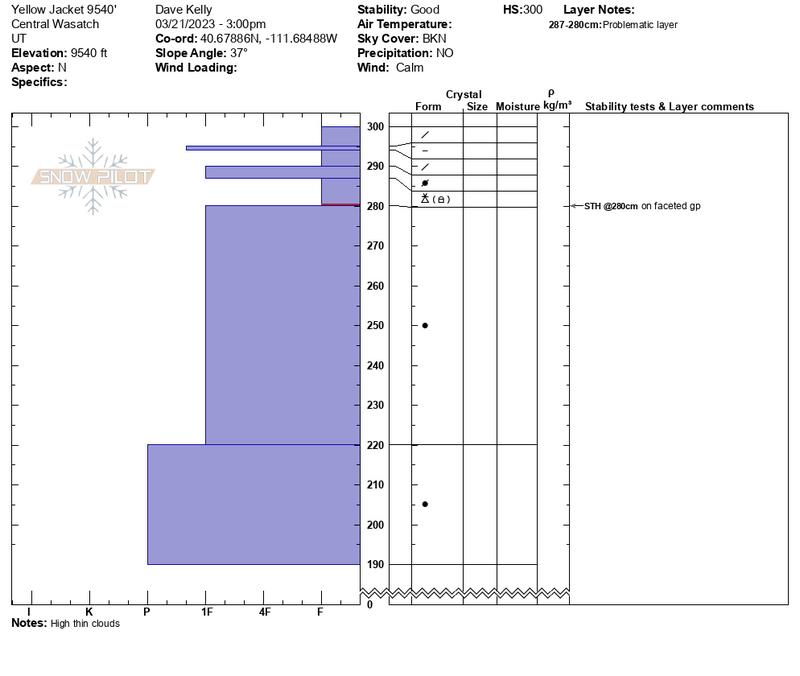
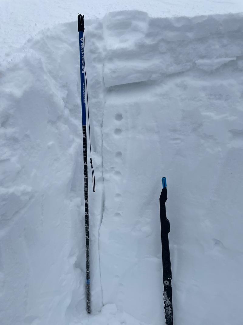
2 snowpits one on an east facing slope (above photo) and one on a north facing slope (below photos). Similarities were that both pits had weaknesses in the upper foot of the snowpack. Both had failures on layers of faceted graupel. This layer of graupel will most likely heal. The layer of concern was closer to the surface and we believe was the cause of the avalanche we observed in Depth Hoar Bowl. Warm temperatures this afternoon should prevent these layers from being of further concern with new snow loading over the next few days.
Once we hit an elevation of about 8,200,' we hit mank wet snow. The snow (even in the north) took in a lot of heat from there. Many drips off the trees made me wonder why I didn't have skin wax. Tomorrow there will be lots of crust on almost all aspects except for mid and upper-elevation north-facing slopes.
Today's Observed Danger Rating
Low
Tomorrows Estimated Danger Rating
None
Coordinates