Observation Date
1/2/2023
Observer Name
Michael Wessler
Region
Uintas » Ridge Yurt
Location Name or Route
East Fork/Wolverine
Weather
Sky
Overcast
Precipitation
Light Snowfall
Wind Direction
West
Wind Speed
Light
Weather Comments
Consistent snowfall from Friday night through Monday midday kept riding conditions fresh and contributed a steadily increasing load to the snowpack. Winds peaked overnight Friday, howling after midnight but becoming light yet again by Saturday morning. Area was relatively sheltered through the duration of the event. Overcast skies with brief breaks allowed for periods of increased visibility. Total accumulations Friday PM - Monday AM around 20-24" with the bulk occurring on Friday night and Sunday night. New snow was generally very light, likely around 10-12% throughout the event.
Snow Characteristics
New Snow Depth
10"
New Snow Density
Medium
Snow Surface Conditions
Powder
Snow Characteristics Comments
New relatively light density snow skiing well on top of a strong and supportive wind-packed layer across the area. Stark differences in depth and stability between S and SE, even greater difference between the weak and shallow southern half and strengthening northern half of the compass.
Red Flags
Red Flags
Cracking
Collapsing
Poor Snowpack Structure
Red Flags Comments
Nearly every step onto new terrain resulted in whumpfing, with connected low-angle slopes producing some of the more unsettling rolling thunder our Wasatch-based selves have heard in a while. One particular collapse on an ENE 9450' slope generated multiple visible cracks across the slope.
Avalanche Problem #1
Problem
Persistent Weak Layer
Trend
Same
Problem #1 Comments
Still harbording widespread PWL... it is the Uintas after all. Encouraging was the small size of facets with some evidence of rounding on higher elevation slopes with deeper snowpack, though can find quite the rotten pile at the bottom of the pack where locally shallower snowpack exists, especially on SW through SE. Clearly still sensitive outside the highest elevations given all the cracking and collapsing.
Snow Profile
Aspect
North
Elevation
10,000'
Slope Angle
20°
Comments
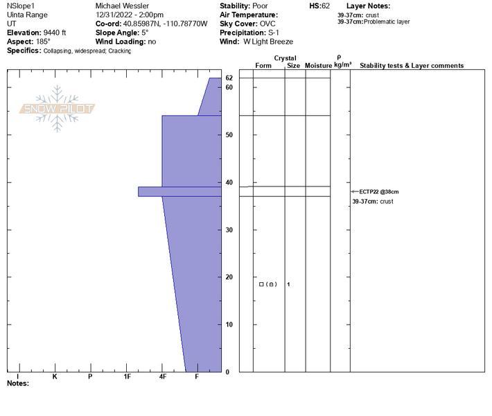
Pits from 12/31 but observation from 3-day trip to Ridge Yurt 12/30-1/2. Noted improving snowpack stability as we moved higher in elevation on N facing slopes, including ECTPX in pit at 15deg @ 9990'. Still a few layers of concern including a mid-pack wind crust. ECTPX but was able to cleanly shear the upper P slab along this layer. Still a dragon lurking in the dungeon below with a mix of primarily angular and some (starting to) round facets. Otherwise, overall weak snowpack on SW through E slopes and plenty of red flags present to go along with it. Added additional photo of pit from S @ 9440'. Great quality skiing on lower angle slopes and plenty of solitude.
Today's Observed Danger Rating
High
Tomorrows Estimated Danger Rating
High
Coordinates