Observation: Park City Ridgeline

Observation Date
12/5/2022
Observer Name
Deutschlander & Gill
Region
Salt Lake » Park City Ridgeline
Location Name or Route
Wasatch Back
Weather
Sky
Overcast
Precipitation
Moderate Snowfall
Wind Direction
Southwest
Wind Speed
Light
Weather Comments
Storm came in a tad later than anticipated but showed up nonetheless. Small .5mm turned into big fat fluffy 5mm flakes in a few hours.
Snow Characteristics
New Snow Depth
6"
New Snow Density
Low
Snow Surface Conditions
Powder
Red Flags
Red Flags
Poor Snowpack Structure
Red Flags Comments
The November drought layer was evident from South to North on the compass. Of the positive test results we had today; they all failed around the drought layer.
Avalanche Problem #1
Problem
Persistent Weak Layer
Trend
Same
Problem #1 Comments
Capped by a melt freeze on South @ 9300ft, ~60cm off ground @9600ft on the North end of the compass.
Snow Profile
Aspect
Southeast
Elevation
9,400'
Slope Angle
23°
Height of snow was 57cm on this SSE pit at 9400ft. Grains were warm, clumping and almost moist from October snow.
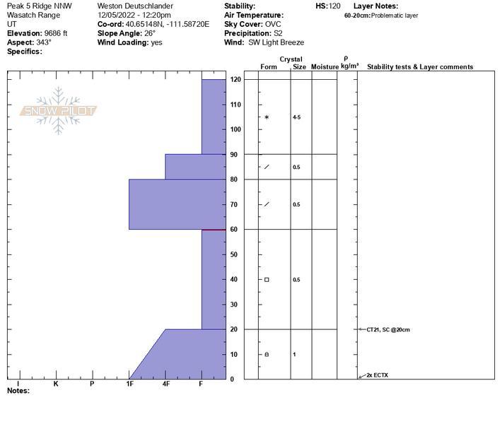
Height of snow was 120cm on this NW pit @ 9600ft
Today's Observed Danger Rating
Considerable
Tomorrows Estimated Danger Rating
Considerable
Coordinates