Observation Date
12/4/2022
Observer Name
Brackelsberg
Region
Salt Lake » Park City Ridgeline » Murdock Peak
Location Name or Route
Park City Ridgeline: Murdock Peak
Weather
Sky
Obscured
Precipitation
Light Snowfall
Wind Direction
Southwest
Wind Speed
Strong
Weather Comments
Sky was completely obsured in the morning. Light snow fell from around 11 AM to 1 PM. Around 2 PM the some of the clouds broke.
Lower elevations got very warm.
Snow Characteristics
Snow Surface Conditions
Dense Loose
Snow Characteristics Comments
Dense, supportable snow surface up high. Lower elevation exit was very warm and wet with rollerballs.
Red Flags
Red Flags
Wind Loading
Collapsing
Poor Snowpack Structure
Red Flags Comments
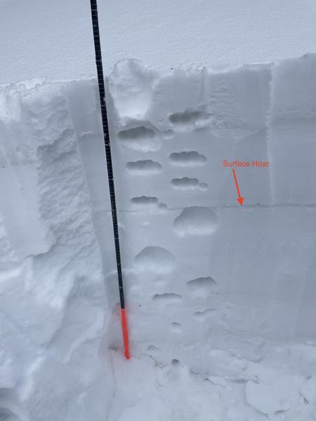
Most of the snowpack was faceted. There was a layer of buried, preserved surface hoar below last week's storm snow.
Avalanche Problem #1
Problem
Persistent Weak Layer
Trend
Same
Problem #1 Comments
The biggest concern is the faceted snowpack which comprised the bottom ~75cm of snow. It appeared that some of the facets were gaining strength. The buried layer of surface hoar on top of the facets and below the new snow was the biggest problem today.
Snow Profile
Aspect
North
Elevation
8,900'
Slope Angle
21°
Comments
We had easy pit results. The layer of surface hoar was easily visible in the snowpit wall (see photo). This surface hoar layer was very reactive to our stability tests. With more snow in the forecast, this layer is a concern.
Today's Observed Danger Rating
Considerable
Tomorrows Estimated Danger Rating
Considerable
Coordinates