Observation: Grizzly Gulch

Observation Date
1/12/2022
Observer Name
John Lemnotis
Region
Salt Lake » Little Cottonwood Canyon » Grizzly Gulch
Location Name or Route
Grizzly Gulch
Weather
Sky
Clear
Wind Speed
Calm
Weather Comments
Warm daytime temps heated solar aspects, expect crusted snow on SE-S-W in the morning.
Red Flags
Red Flags
Poor Snowpack Structure
Red Flags Comments
We still have a poor snowpack structure on many polar aspects and that trumps strength. If you go out and look for a strong deep snowpack you will find it, also, if you go out and look for a weaker more shallow snowpack you will find it. That is the problem right now, we still have the ability to trigger large daily avalanches although the likelihood is low. These avalanches could be triggered in shallow snowpacks or near buried trigger points that you don't know are there. The strong, deep areas of the snowpack will give you feedback that you want to go ski steep north facing shots while the shallow more weak areas should still send you running for the hills.
Avalanche Problem #1
Problem
Persistent Weak Layer
Problem #1 Comments
The PWL is gaining strength but we should not lay this problem to rest yet.
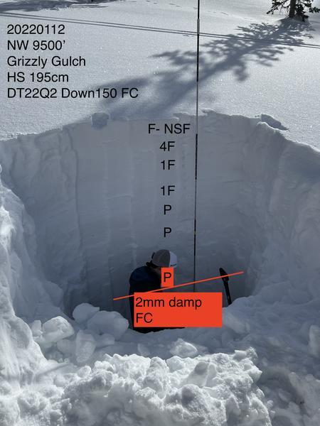
Within our group we dug 2 snowpits today and I will comment on the one that I dug. As pictured NW facing 9500' in Grizzly, HS 195cm with a deep hard slab on top of 45cm FC at the ground. The facets were damp and gaining strength. Doing a CT or ECT in this snowpit would be inappropriate as the weak layer is buried greater than 120cm deep. Instead we performed a deep tap test and recorded DT22 Q2. While it would be hard for a skier or rider to trigger an avalanche on this deep layer the consequences are dire. In our adjacent snowpit about 100' away the HS was more shallow and was weak in terms of strength. The weak points are where we can trigger avalanches right now, they are the worst case scenario and they are out there.
Today's Observed Danger Rating
None
Tomorrows Estimated Danger Rating
None
Coordinates