Observation Date
1/6/2022
Observer Name
Kelly
Region
Salt Lake » Big Cottonwood Canyon » Tuscarora
Location Name or Route
Tuscarora
Weather
Sky
Overcast
Precipitation
Light Snowfall
Wind Direction
Southwest
Wind Speed
Moderate
Weather Comments
Riming noted on trees. Winds were consistent Moderate out of the SW. Overcast to obscured skies with some visibility back into Big Cottonwood Canyon.
Snow Characteristics
New Snow Depth
2"
New Snow Density
High
Red Flags
Red Flags
Heavy Snowfall
Wind Loading
Poor Snowpack Structure
Red Flags Comments
I went looking for areas that were more wind scoured to see if I could find a more shallow snowpack in the high elevation. I did not note any recent natural avalanches in my travels (visibility was limited). Previous heavy snowfall with storm totals up to 19" snow and 4" water on top of poor structure with wind loading.
Avalanche Problem #1
Problem
New Snow
Trend
Decreasing Danger
Avalanche Problem #2
Problem
Persistent Weak Layer
Trend
Same
Problem #2 Comments
The persistent weak layer is still out there and still being activated. In deeper snowpack zones it appears to be healing, but the spatial variability leads me to not trust steep slopes with a persistent weak layer and a slab on top regardless of depth of snowpack.
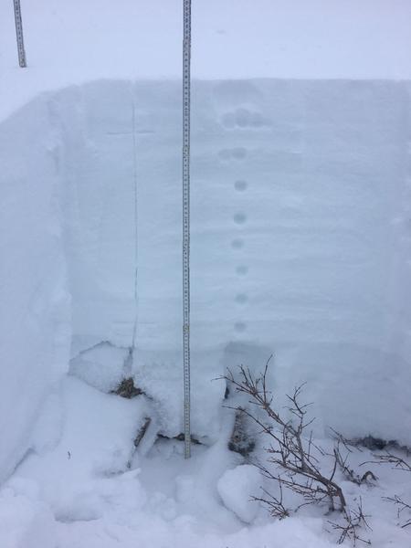
Snow Profile
Aspect
Southwest
Elevation
10,500'
Slope Angle
29°
Comments
Previous travel plan for the day as well as snow pit information led me to stick with southerly facing slopes under 30 degrees. There was still good skiing to be had. This was one of the worst profiles I've seen in quite some time. Any more steepness or additional 1 finger slab over the weak layer would have made me apprehensive to ski that slope.
Today's Observed Danger Rating
Considerable
Tomorrows Estimated Danger Rating
Considerable
Coordinates