Observation Date
12/22/2021
Observer Name
Hardesty, Wilson, Diegel, Patterson
Region
Salt Lake » Little Cottonwood Canyon » White Pine
Location Name or Route
White Pine
Weather
Sky
Overcast
Precipitation
Light Snowfall
Wind Direction
Southwest
Wind Speed
Moderate
Snow Characteristics
Snow Surface Conditions
Faceted Loose
Wind Crust
Melt-Freeze Crust
Snow Characteristics Comments
Wind, clouds, and warmth starting to deteriorate weak surface snow. Areas of surface hoar were laying down if present at all. Upper elevations exceedingly wind affected (upper White Pine on southwest flow, anyone?)....whereas mid/low elevation northerly snow surfaces warm; even damp at mid/low transitional zone.
Red Flags
Red Flags
Wind Loading
Collapsing
Poor Snowpack Structure
Red Flags Comments
One collapse on PWL noted at 9700' north facing
Avalanche Problem #1
Problem
Persistent Weak Layer
Trend
Increasing Danger
Problem #1 Comments
PWL to be taking a significant amount of loading over the next week or so and will become dangerous. Despite ECTX on westerly at 10k, I suspect that the loading will tip many slopes toward avalanching. No cracking/collapsing noted.
Avalanche Problem #2
Problem
Wind Drifted Snow
Trend
Increasing Danger
Problem #2 Comments
Hard slabs abound. No hollow sounding wind slabs, but extensive scouring and drifting noted everyone in the upper elevations.
SIGNIFICANT SCOURING AND DRIFTING UPPER ELEVATIONS WHITE PINE - HIGH VARIABILITY
Snow Profile
Aspect
West
Elevation
10,000'
Comments
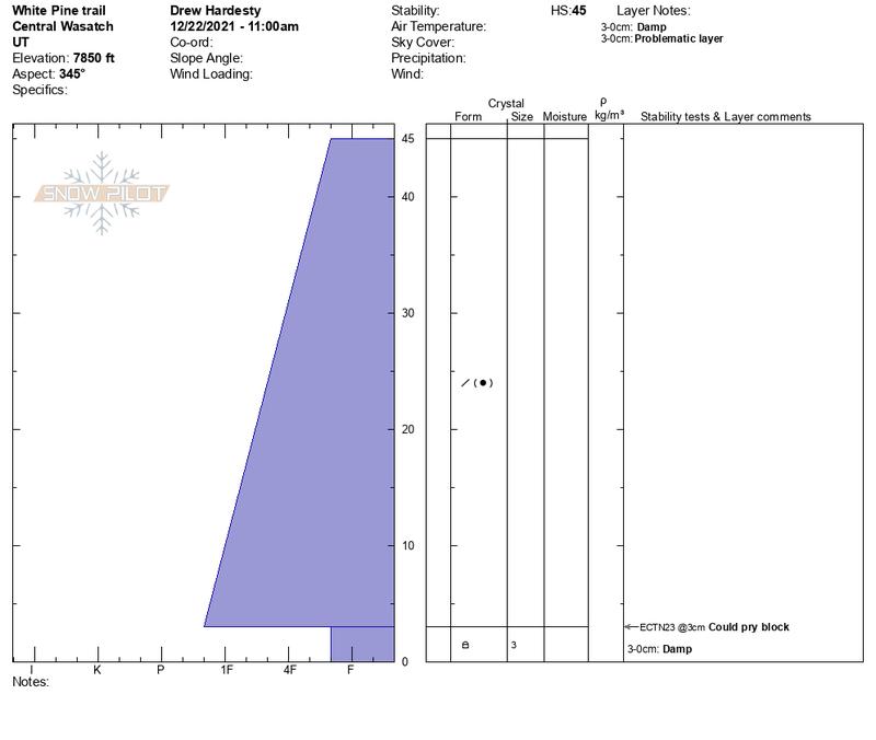
Wanted to look at low elevations as well. Pit on NNW aspect at 7850'. HS - 45 cm with lowest 3cm at the ground damp 3mm rounding facets. Transitional northerly aspects from low/mid will be suspect with enough load on this PWL.
Today's Observed Danger Rating
Considerable
Tomorrows Estimated Danger Rating
None


