Check out our Holiday Auction - Sign Up for the Utah Snow and Avalanche Workshop (USAW)

Observation: Murdock Peak

Observation Date
12/15/2021
Observer Name
Brackelsberg
Region
Salt Lake » Park City Ridgeline » Murdock Peak
Location Name or Route
Park City Ridgeline
Weather
Sky
Broken
Wind Direction
West
Wind Speed
Strong
Weather Comments
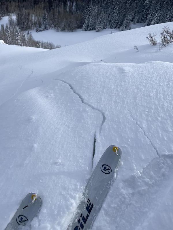
The strong winds continued to transport the new snow. The ridgelines had sensitive wind slabs with significant propagating cracks.
Snow Characteristics
New Snow Depth
12"
New Snow Density
Low
Snow Surface Conditions
Powder
Wind Crust
Red Flags
Red Flags
Heavy Snowfall
Wind Loading
Cracking
Collapsing
Poor Snowpack Structure
Red Flags Comments
The strong winds produced very senstive wind slabs with significant cracking and collapsing. Cracks were propagating long distances. The wind continued to blow hard through the morning transporting a significant amount of the new snow.
Avalanche Problem #1
Problem
Persistent Weak Layer
Trend
Same
Problem #1 Comments
I was curious to see an area that had a very small amount of early season snow and to see how this compared to some nearby areas that had more early season snow. This location did not have the same multiple crust/facet layers as I found on Satruday. There was a significant and reactive facet layer that easily failed on stability tests.
Avalanche Problem #2
Problem
Wind Drifted Snow
Trend
Increasing Danger
Problem #2 Comments
The wind continued to blow hard through the morning. With the amount of snow being transported I would expect sensitive wind slabs and cornices to keep growing. The wind slabs we encountered were 4F in hardness but produced significant cracking and collapsing.
Snow Profile
Aspect
Northeast
Elevation
8,600'
Slope Angle
28°
Comments
The facet layer below the 10 Oct snow was very sensitive to our stability tests with a CT4 and ECTP11.
Today's Observed Danger Rating
High
Tomorrows Estimated Danger Rating
Considerable
Coordinates