Observation Date
3/20/2021
Observer Name
BCI Level
Region
Uintas » Tower Mountain
Location Name or Route
Tower Mt-Current Creek Peak
Weather
Sky
Overcast
Precipitation
Light Snowfall
Wind Direction
North
Wind Speed
Moderate
Weather Comments
Winds were ripping up high in the alpine today from the NW transporting snow from the lee sides of west facing slopes to the east. At about 2pm the wind started to subside, visibility dropped and snow began to fall at well over a inch per hour. The heavy snow continued throughout the late afternoon and into the early evening delivering at least 6 to 8" of fresh snow down to about 7500 feet.
Snow Characteristics
New Snow Depth
8"
New Snow Density
Medium
Snow Surface Conditions
Dense Loose
Wind Crust
Melt-Freeze Crust
Snow Characteristics Comments
Before the incoming storm we found that most areas of snow along our route was mostly baked with a surface melt freeze crust. However, we did find a few pockets of sheltered and shaded north facing slopes with some creamy surface snow which made for better riding. At about 2pm heavy snow started to fall at over and inch per hour and by the time we headed back to the TH (4pm) there was at least 6 to 8" of fresh and the snow was still falling. Overall it was the beginning of a nice reset for the range and Sunday riding conditions should be favorable.
Red Flags
Red Flags
Heavy Snowfall
Wind Loading
Avalanche Problem #1
Problem
Wind Drifted Snow
Trend
Increasing Danger
Problem #1 Comments
Winds were still ripping up high in the alpine during around Tower Mountain and north to Heber mountain. Be careful as this will produce fresh wind slabs on E and NE facing slopes.
Avalanche Problem #2
Problem
New Snow
Trend
Increasing Danger
Problem #2 Comments
Heavy snow was falling at a high rate adding additional weight to the snowpack which could wake things up a bit. Be careful and watch out for natural avis and wind loaded slopes.
Snow Profile
Aspect
North
Elevation
9,900'
Slope Angle
28°
Comments
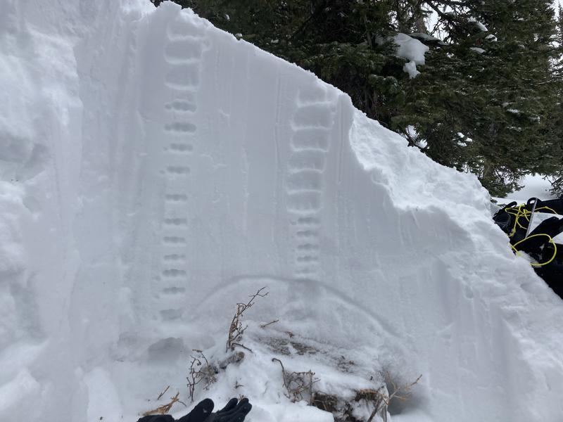
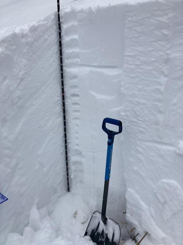
Our snow pit was unreactive to an ECT stability test. However, the weak layer (photos below) near the ground that has been in the snowpack since November is still there, and it is not going anywhere. Even though the snowpack is quiet at the moment if and avi is triggered at this layer it is going to be deep, heavy, and destructive. You will notice in the photo below that this weak layer of snow goes up and over the top of a stump (closer to the surface/trigger point). This is great example of a avalanche trigger point.
Today's Observed Danger Rating
Moderate
Tomorrows Estimated Danger Rating
Considerable
Coordinates