Observation Date
2/16/2021
Observer Name
Greg Gagne - Dave Pease
Region
Salt Lake » Mill Creek Canyon » Porter Fork » Main Porter
Location Name or Route
Main Porter Fork
Comments
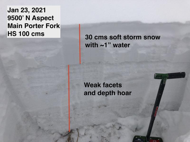
The photo from below is of a snowpit I dug at 9,300' in Main Porter on January 23. It shows the very poor structure, with weak facets and depth hoar in the bottom 60-75 cms of the snowpack. The only difference is there is now a 1-1.5 meter slab on top. There have been very large natural avalanches in Millcreek Canyon the past few weeks, and recently in West Porter and also In Between in Main Porter. The runouts for these slides are running very long distances, much further than is expected.
It is pretty simple - expect very large and dangerous avalanches that are with ~25-year returns, and possibly creating new avalanche paths.
The avalanche danger on 2/16 was rated as "Extreme" which is defined as (1) "natural and human triggered avalanches are certain", (2) "large to very large avalanches in many areas", and (3) "avoid all avalanche terrain". While performing field work today, we adhered to this travel advice and avoided slopes > 30° (in fact we traveled on slopes significantly less steep) and avoided avalanche runout zones.
Today's Observed Danger Rating
Extreme
Tomorrows Estimated Danger Rating
Extreme


