Observation Date
2/11/2021
Observer Name
Greg Gagne & Dave Pease
Region
Salt Lake » Mineral Fork
Location Name or Route
Mineral Fork
Weather
Sky
Overcast
Precipitation
Light Snowfall
Wind Direction
West
Wind Speed
Light
Weather Comments
Light S-1 snowfall with moderate gusty westerly winds in exposed terrain.
Snow Characteristics
New Snow Depth
2"
New Snow Density
High
Snow Surface Conditions
Powder
Dense Loose
Wind Crust
Damp
Snow Characteristics Comments
~5 cms dense new snow above 8,500'. Wind drifts formed from wind events the past few days were unreactive to stability tests. HS is very variable, with roughly 60-100 cms between 7,500' and 9,000'
Red Flags
Red Flags
Poor Snowpack Structure
Comments
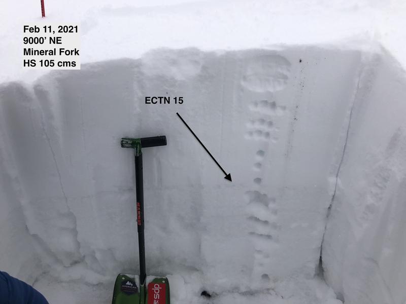
The biggest take-home today was the wide variability in snowpack depths on northeast and northerly aspects. The winds have stripped some exposed snow surfaces, leaving a shallow, faceted snowpack in place. While on adjacent slopes a denser 60 cm slab is on top of the faceted snow near the ground. Stability tests today showed poor structure with strong snow over weak snow, but ECTN.
The recent warmth has helped stiffen the snow surface, but above ~8,500' the facets underneath are very weak.
We noticed two avalanches that likely slid earlier this week. These were reported under avalanche occurrences: Highline and Moonlight. Moonlight is a natural avalanche, but unsure of Highline as there are tracks adjacent to the avalanche so it is possible it was remotely-triggered.
Today's Observed Danger Rating
Considerable
Tomorrows Estimated Danger Rating
Considerable