Observation: Upper Weber Canyon

Observation Date
2/11/2021
Observer Name
jg
Region
Uintas » Upper Weber Canyon
Location Name or Route
Weber Canyon
Weather
Sky
Broken
Wind Direction
Southwest
Wind Speed
Moderate
Weather Comments
Mostly clouds skies with very light snow at times. Winds were a bit swirly where we were but prevailing winds were generally moderate from the SW. Temps in the upper teens and low twenties.
Snow Characteristics
New Snow Depth
1"
New Snow Density
Medium
Snow Surface Conditions
Powder
Dense Loose
Snow Characteristics Comments
The wind seemed to be a player last night and today so it was difficult to tell how much snow fell yesterday, but an inch or two would be my guess. The snow was creamy and fun. Occasionally punchy skiing and riding when you'd encounter spots with a thinner slab making it easier to punch into the facets. Sandboxing at times climbing in lower elevation terrain. Obvious signs of the winds from last weekend at all elevations. Small amount of graupel on the snow surface.
Red Flags
Red Flags
Recent Avalanches
Poor Snowpack Structure
Red Flags Comments
We stayed out of upper elevation wind loaded terrain. Poor snowpack structure was the biggest concern.
Avalanche Problem #1
Problem
Persistent Weak Layer
Trend
Increasing Danger
Problem #1 Comments
Very poor structure. While I felt today's danger was moderate in the terrain we traveled, which was from low to upper mid elevations (7500-10K) on the north half of the compass, it will clearly be another story tomorrow due to the incoming storm.
Snow Profile
Aspect
Northwest
Elevation
9,900'
Slope Angle
25°
Comments
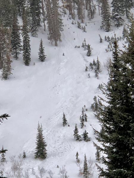
Saw several slides similar to the one in the photo. All had an easterly component to them and looked to have naturally released during the last big storm.
Results in pit test were stubborn with no propagation across the column in ECT tests. That being said, if we get the water weight that's forecasted, the snowpack is going to come to life and the danger is going to rise to considerable or high. I got very clean, Q1 quality shears on faceted grains at 41cms down (16"). I can see avalanches failing on this persistent weak layer and stepping down to the deeper PWL once we get more weight on the pack. We're almost certainly going to go through another natural avalanche cycle over the next few days.
Today's Observed Danger Rating
Moderate
Tomorrows Estimated Danger Rating
Considerable
Coordinates