Observation: Cutler Ridge

Observation Date
2/4/2021
Observer Name
Hardesty
Region
Ogden » Ben Lomond » Cutler Ridge
Location Name or Route
Cutler Ridge
Weather
Sky
Overcast
Precipitation
Light Snowfall
Wind Direction
West
Wind Speed
Moderate
Weather Comments
New snowfall maybe added up to a trace.
Snow Characteristics
New Snow Depth
2"
New Snow Density
Medium
Snow Surface Conditions
Powder
Wind Crust
Melt-Freeze Crust
Rain-Rime Crust
Snow Characteristics Comments
Appears that the pre-frontal rain/snow line reached maybe 8k on Wednesday; all aspects have some fall-out from that - either some friable crusts at low elevations or 2mm rain crust in the mid-elevations. This is now buried under a couple inches of small diameter graupel that fell during frontal passage. In the mid/upper elevation transition zone, the early week heat wave has taken its toll with thermal crusts on all aspects; again now buried by a couple inches of new...or otherwise scoured by the winds. One could see rollerballs on some northwest slopes at 8k. Low elevations have this superficial structure but damp below to the ground.
Red Flags
Red Flags
Recent Avalanches
Poor Snowpack Structure
Comments
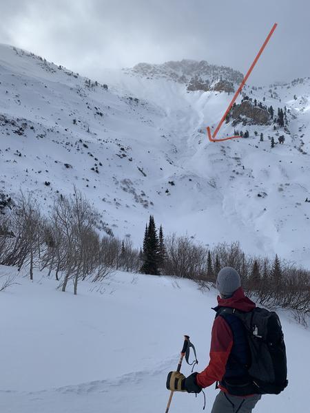
No obvious signs of instability in the tour up to just below the Ben Lomond/Ogden skyline ridge. The large D3 as noted by Brandt, others is impressive. We noted a smaller east facing pocket at 8600' that had sympathetically released with the larger slide. It also went to the ground.
I hunted for any sign of Jan 22 weakness but could not find any.
Photos:
1 - Long time observer Lee Fortin looking up at the Feb 3 natural adjacent to Willard Peak.
2 - thin rain crust up to 8000'.
Today's Observed Danger Rating
Considerable
Tomorrows Estimated Danger Rating
Considerable