Observation Date
12/27/2020
Observer Name
Wilson, Hardesty, Fox-Shapiro
Region
Salt Lake » Little Cottonwood Canyon » White Pine
Location Name or Route
White Pine
Comments
Hadn't yet been to White Pine this season, wanted to check out coverage and look for recent avalanche activity. Also interested to see if poor snowpack structure, weak snow, and propagation potential was still a concern on the off aspects (southeast to southwest).
We did not see any indication of recent avalanching in the drainage, but we did have several large collapses with cracking. These occurred on a west aspect at 9,400', a north and a northeast aspect at 9,600', and a north aspect at 10,000 feet. As Greg said in his Christmas forecast, the snowpack was talking and the message was not "Happy Holidays".
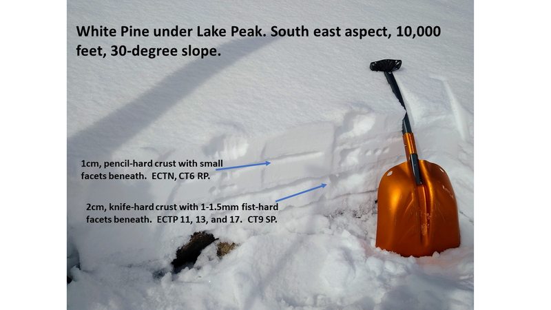
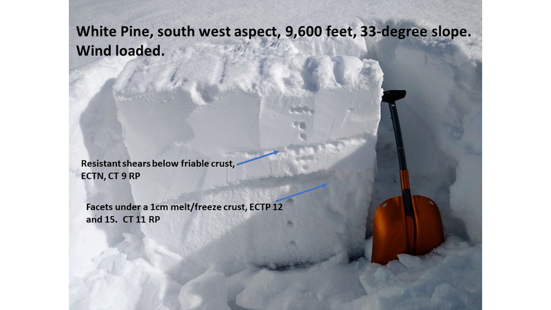
We didn't dig on these known weak areas on the shady aspects as we had enough info. We instead dug quick test-pits on upper elevation southeast and southwest and at lower elevation west locations, where the snowpack wasn't giving any audible feedback. All had poor snowpack structure with harder snow over weaker faceted snow within the top 15-30cm of the surface. Fractures on this layer were easy or moderate to initiate, and all had propagation. Friction with the bed surface varied.
Despite these results, a handful of short-but-steep test slopes on a variety of aspects failed to produce avalanches.
In short, the danger is beginning to move towards "scary moderate". The slab is more consolidated, signs of instability are present (cracking, collapsing, poor snowpack structure, propagation in tests), but avalanches are less likely. In the upper elevation SE and SW, and perhaps at a few isolated lower elevation pockets, a reticent PWL avalanche might yet be found. The likelihood is much lower.
Final note: Wind had heavily impacted the drainage down to mid-elevations, with 2-inches of new snow hiding much of it. New snow bonded relatively well to the surface in terrain traveled today.
Coverage was fine for travel, but still thin! Photos show the bouldery landscape, and hint at the wind-impacted snow.


Gratuitous blue-sky photo. We had steeled ourselves for gray-bird conditions but were pleasantly surprised!

Today's Observed Danger Rating
Considerable
Tomorrows Estimated Danger Rating
None
Coordinates


