Observation Date
12/14/2020
Observer Name
Greg Gagne
Region
Salt Lake » Little Cottonwood Canyon » Catherine's Pass
Location Name or Route
Upper LCC / Alta Periphery (Catherines, Rocky Point, Dry Fork)
Weather
Sky
Obscured
Precipitation
Light Snowfall
Wind Direction
Northwest
Wind Speed
Light
Weather Comments
Winds were generally light. The atmosphere felt saturated with periods of dense fog.
Snow Characteristics
New Snow Depth
2"
New Snow Density
Low
Snow Surface Conditions
Powder
Wind Crust
Snow Characteristics Comments
An under-producing storm with only 3-5 cms of new snow. Storm snow since Friday has settled to 20-25 cms. Wind drifts along exposed ridges were sensitive and would crack where they were on top of weaker snow.
Red Flags
Red Flags
Recent Avalanches
Cracking
Collapsing
Poor Snowpack Structure
Red Flags Comments
Quite a bit of cracking on steep slopes. Beginning to get some localized collapsing as well.
Avalanche Problem #1
Problem
Persistent Weak Layer
Trend
Increasing Danger
Problem #1 Comments
As the recent storm snow gains strength and acts more as a cohesive slab we are beginning to see signs of an obvious PWL problem (recent avalanches, cracking, collapsing). Extended column tests the past few days were all ECTN, but today getting ECTP (< 10). Just not that much weight yet, but we clearly are getting there.
Tuesday should be dry, but winds are forecasted to increase, and wind-drifting may be enough to overload some slopes.
Snow Profile
Aspect
North
Elevation
10,200'
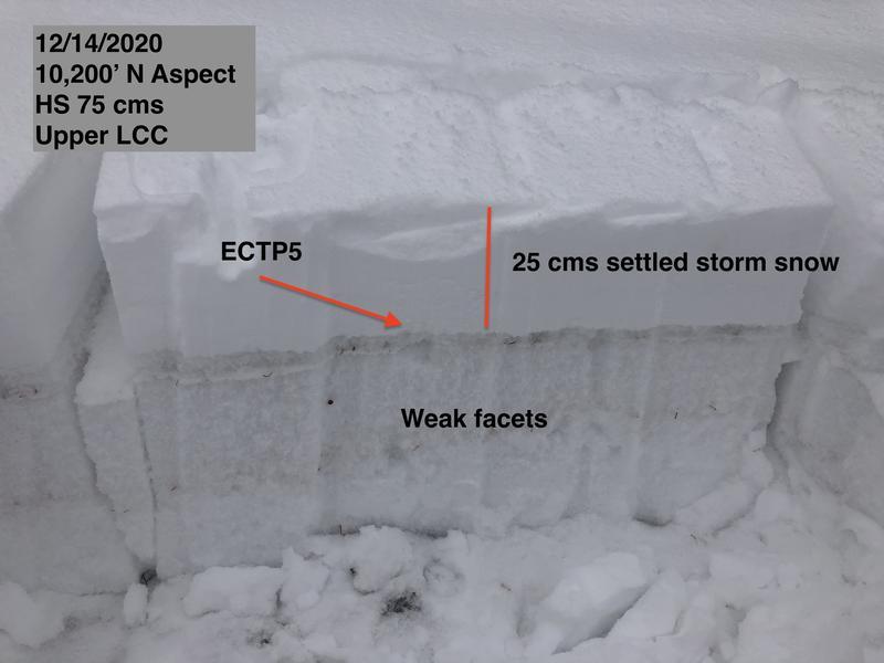
Comments
The storm snow was much slabbier today and it showed with cracking, collapsing, and full-propagation extended column tests. I am finding the weakest snow to be the old snow surface that is buried under the weekend storm snow. This 5 cm layer is very weak, large-grained near-surface facets. (Photo below.)
Today's Observed Danger Rating
Considerable
Tomorrows Estimated Danger Rating
Considerable