Observation: Big Springs

Observation Date
3/8/2020
Observer Name
Wilson, Hardesty
Region
Provo » Provo Canyon » South Fork Provo R. » Big Springs
Location Name or Route
Big Springs
Weather
Sky
Obscured
Precipitation
Moderate Snowfall
Weather Comments
Precipitation throughout the tour, with rain at the parking lot and snow above roughly 6,500. Intensity increased around 4pm, and stayed heavy for next two hours. Changed from graupel and heavily-rimed flakes to lightly-rimed flakes. Calm winds, warm temps.
Snow Characteristics
New Snow Depth
9"
New Snow Density
High
Snow Surface Conditions
Powder
Damp
Snow Characteristics Comments
Below 6,200 feet the snow surface was completely wet, with rain falling. Most aspects were melted down to the ground and the Big Springs road had running water. From 6,200 to 6,800 snow was falling but only a cm accumulated; everything else melted as it landed. Sticky! From there to roughly 8,300' we had graupel overlying wet snow. Boot penetration was up to the thigh and deep-gouging push-a-lanches were easy to trigger. From 8,300' to our high-point at 9,700' the old snow surface was supportable: thick and damp towards the bottom, dry and thin up high. Wet new snow bonded well to the old surface, and the dense graupel made for great skiing with no bottom-feeding.
Red Flags
Red Flags
Heavy Snowfall
Red Flags Comments
Winds lighter than expected.
Avalanche Problem #1
Problem
Wet Snow
Trend
Decreasing Danger
Problem #1 Comments
No evidence of natural wet activity, but in the lower elevations a good kick got snow moving and gouging 30" deep. Seemed like wet activity could pose a problem in terrain traps but not much else. Not as dramatic as it might have been had the rain fallen on dry snow.
Snow Profile
Aspect
West
Elevation
9,500'
Slope Angle
20°
Comments
We dug pits on West aspects 8,050' and 9,450' for comparison
At the lower elevation there was a 2.5 cm moist crust just under the storm snow, with moist fist-hard snow below. Below that, two rain crusts down 30cm and 45cm, with some water-pooling noted on the lower crust. No activity in compression or extended column tests.
At the upper elevation there was no wet layer. Compression test had Q2 failure under a 1.5cm crust on rounding facets but was difficult to trigger (CT 22). No propagation in the extended column test (ECTN 18, same layer).
Photos of lower and then upper pits.
Below:
Photos: Low elevation slopes (but not the meadows!) were bare, upper elevations got a thick coat of graupel.
Videos: Push-a-lanches below 8,000', a wet entrance and exit. None of the good surfy skiing captured on camera.
Video
Video
Really a good storm for Provo!
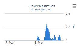
Screen capture of water amounts, at 1.04" SWE from Bunne'ls, this area did just as well us the upper Big Cottonwood and better than Little Cottonwood. When you go high enough, of course..
Video of snow-globe after precip-type switched from graupel to large flakes.
Danger was low and skiing was great in the upper elevations. Moderate for wet activity in the lower elevationss
Today's Observed Danger Rating
Moderate
Tomorrows Estimated Danger Rating
None
Coordinates