Observation Date
2/8/2020
Observer Name
Brackelsberg/Caplis
Region
Uintas
Location Name or Route
Gardner Fork
Weather
Sky
Clear
Weather Comments
The morning was clear with clouds moving in after 12, the wind picking up shortly after that, and light snow started falling around 2:30.
Snow Characteristics
Snow Surface Conditions
Dense Loose
Snow Characteristics Comments
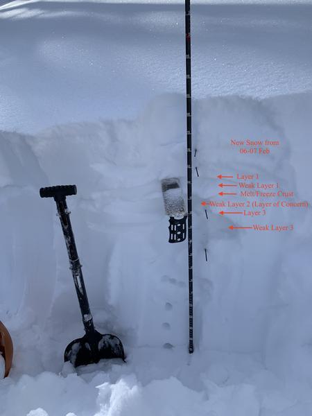
The snow was settling quickly and was very supportable. There were 3 noticeable crusts on all aspects that we did hand pits or a full pit.
Red Flags
Red Flags
Recent Avalanches
Heavy Snowfall
Wind Loading
Collapsing
Poor Snowpack Structure
Red Flags Comments
Lots of red flags today. We saw a snowmobile triggered avalanche from a distance. Above tree line the new snow was blown away and we were skinning on the melt/freeze crust from last weekend. We had limited, small collapsing. The multiple layers in the snowpack were very concerning for us.
Avalanche Problem #1
Problem
Persistent Weak Layer
Trend
Same
Problem #1 Comments
The weak layer below last weekends melt/freeze crust was our biggest concern today.
Avalanche Problem #2
Problem
Wind Drifted Snow
Trend
Same
Problem #2 Comments
We mostly avoided higher, wind-affected elevations, but poked into them to be confirmed that the effect of the wind was significant.
Snow Profile
Aspect
Northeast
Elevation
9,600'
Slope Angle
28°
Comments
The snow was noticeably settling during the day today. Our snow pit results were in line with the avalanche forecast for the day. the weak layer below last weekend's melt/freeze crust was very sensitive to both the CT and ECT. We avoided all terrain over 30 degrees. With the amount of weight on top of the melt/freeze crust, I think this layer could be a concern for quite a while.
Today's Observed Danger Rating
Considerable
Tomorrows Estimated Danger Rating
Considerable
Coordinates