Observation: Uintas

Observation Date
1/30/2020
Observer Name
Kikkert
Region
Uintas
Location Name or Route
Upper Weber Canyon
Weather
Sky
Obscured
Wind Direction
North
Wind Speed
Moderate
Weather Comments
Winds bumped up for a couple hours mid-morning bordering on strong - otherwise they were in the moderate category. Winds brought in very dense fog and rime. Snow surface didn't seem to rime - but any man made objects - including me - rimed quickly.
Snow Characteristics
New Snow Depth
2"
New Snow Density
Medium
Snow Surface Conditions
Powder
Snow Characteristics Comments
1.5-2" new from the quick wave that passed through morning of the 30th. Winds had rippled much of the snow surface - but at least where we were didn't completely scour the snow or form much in the way of wind slabs
Avalanche Problem #1
Problem
Persistent Weak Layer
Trend
Same
Problem #1 Comments
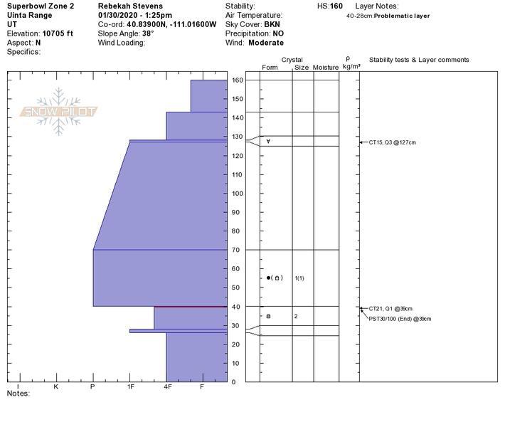
Have dug a couple pits in upper elevation north facing terrain the last couple days looking at our buried persistent weak layers. This terrain has not been skied yet this year, but has avalanched at least once. A couple take-aways so far. 1) In lower angle terrain that did not avalanche previously the snowpack is deep and the early season facets are rounding with good results in stability tests (i.e., no propagation). In terrain that likely avalanched during the Thanksgiving cycle, the snowpack is shallower and weaker. These areas likely were thin during early December when there was some cold weather that may have led to additional faceting. 2) other take-away from looking in this north facing terrain is that I'm not noticing the late December facets. See snowpits below.
Snow Profile
Aspect
North
Elevation
10,300'
Today's Observed Danger Rating
Moderate
Tomorrows Estimated Danger Rating
Moderate