
Observation Date
3/24/2019
Observer Name
Wilson, Hardesty
Region
Salt Lake » Little Cottonwood Canyon
Location Name or Route
White Pine, then Twin Lakes
Video
Tomorrow's forecast seems ripe for wet activity: 44-48 degree temps at Alta Guard, and sunny. If the forecast verifies, that combination could certainly impact the foot of new (albeit dense) snow on solar aspects. If light cloud cover leads to more greenhousing than expected, we might see north get into the game at more than just the lower elevations.
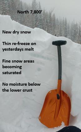
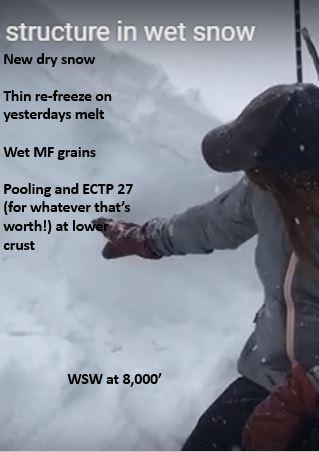
We dug 9 quick pits to see what snow underlies tomorrow's could-be mush.
On all but mid and upper elevation northerly aspects, the new snow landed on a crust. In some locations the crust was thick and frozen, full melt freeze for inches. At others, the top cm was barely re-frozen above loose melt freeze forms, with plenty of water pooling down even 50cm. On lower elevation north, the snow below the thin crust had been dry until yesterday, but now is becoming saturated in the top 10cm. Despite a clearing night and lower temps, the blanket of new snow should insulate the wet layers and keep the snowpack relatively warm.
Yesterdays sun was patchy, so the pattern crust pattern is probably variable.
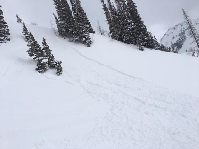
Big picture: new snow could run naturally as wet loose and small wet slab on crust on many solar aspects and low to mid elevation northerlies. On these mid/low esp low northerlies, we could see activity stepping down to wet layers below the crust either through gouging or possibly pulling out wet pockety slabs...
Video
Good season for testing snowload calculations! Doesn't this bridge have hand-rails .....?

Danger probably spiked to considerable at height of precip. intensity.
Tomorrow might reach considerable if it's as warm and sunny as forecast.
Today's Observed Danger Rating
Considerable
Tomorrows Estimated Danger Rating
Considerable


