Observation Date
3/21/2019
Observer Name
evelyn
Region
Salt Lake » Little Cottonwood Canyon
Location Name or Route
Upper Little Cottonwood
Weather
Sky
Overcast
Precipitation
Moderate Snowfall
Wind Direction
Southeast
Wind Speed
Moderate
Weather Comments
Snow fall in the morning, ending around noon. Southeasterly wind speeds strong enough to be annoying when gusting, and drifting snow along ridge lines and well down into bowls.
Snow Characteristics
New Snow Depth
4"
New Snow Density
Medium
Snow Surface Conditions
Powder
Wind Crust
Melt-Freeze Crust
Snow Characteristics Comments
Powder and dense, wind blown powder. Dust on crust on all but a wedge of upper elevation, northerly facing slopes which has nice soft snow beneath the new. Some slopes scoured to the melt freeze crusts by the wind. Upper elevation, due north facing slopes had the best turning (wind sheltered helped), with lower angle slopes the best chance of skimming over the crusts on most other aspects. Hoping for another foot or so to give winter a real comeback.
Red Flags
Red Flags
Recent Avalanches
Wind Loading
Red Flags Comments
Hard to tell with the flat light, but it looked like new sluffs in steep, north facing gullies like the Y, Y-not, Triangle Couloir. Perhaps also the east facing side of Thunder. May have started dry, but looked like they turned into wet sluffs low. But a chance they were older slides with new snow on top.
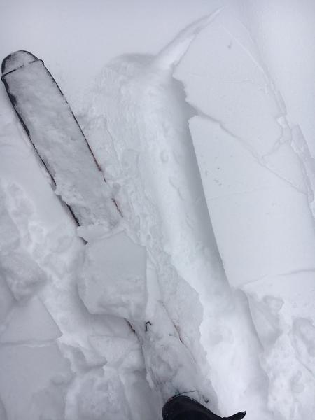
Winds were drifting snow down into open bowls, and down slope. Cracky, vey shallow and soft drifts, but not connecting very far where I was. Failing on the newly buried near surface facets.
Comments
Shallow cracking on the new snow/old snow interface, where the old snow is small near surface facets. This layering will be worth keeping an eye on if the snow adds up over the next few days, especially accompanied by wind. I also had localized cracking/small collapses where the melt freeze sun crust beneath the new snow was thin, failing on dry snow below the crust.
Today's Observed Danger Rating
Low
Tomorrows Estimated Danger Rating
Moderate