Observation Date
3/7/2019
Observer Name
Greg Gagne - Russ Costa
Region
Salt Lake » Little Cottonwood Canyon » White Pine
Location Name or Route
White Pine
Weather
Sky
Obscured
Precipitation
Moderate Snowfall
Wind Direction
West
Wind Speed
Moderate
Weather Comments
Occasional bursts of graupel - totaling 3-5 cms.
Snow Characteristics
New Snow Depth
12"
New Snow Density
High
Snow Surface Conditions
Powder
Damp
Snow Characteristics Comments
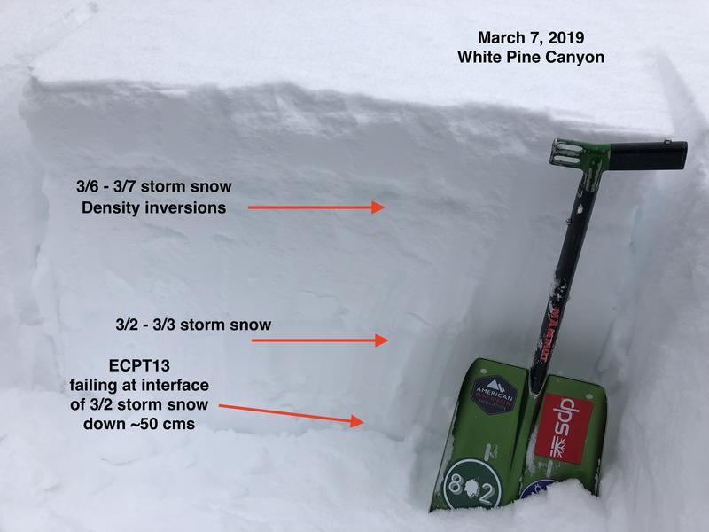
About 30 cms of dense snow that is mostly graupel has fallen since yesterday. Snow below ~8500' had dampened on all aspects. The 30 cms of storm snow has different density inversions.
Red Flags
Red Flags
Recent Avalanches
Heavy Snowfall
Wind Loading
Collapsing
Poor Snowpack Structure
Red Flags Comments
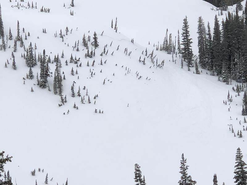
We saw at least 3 avalanches, 2 that were likely natural-triggers, and the third on Lake Peak that was remotely-triggered (these were recorded in avalanche occurrences). We also got several collapses, likely collapsing on one of the density inversions in the top 30 cms of storm snow.
Avalanche Problem #1
Problem
New Snow
Trend
Increasing Danger
Problem #1 Comments
New snow avalanches are failing either within a density inversion in the top 30 cms, or down 40-60 cms on a layer of facets or decomposing fragments (DFs) that is at the interface of the Saturday/Sunday storm. Extended column tests were ECTP, failing between 13 and 23 taps, on the layer of facets/DFs. I am expecting this deeper layer will heal fairly quickly given the warm temperatures of the snowpack, but an additional 1"+ of water with the Friday storm may be reactive on this layer, or within the density inversion.
Avalanche Problem #2
Problem
Wind Drifted Snow
Trend
Increasing Danger
Problem #2 Comments
We did find a few denser wind drifts today, and the Friday storm appears to be windy as well, so additional fresh wind drifts can be expected for Friday.
Comments
The natural and skier-triggered activity today indicated a sensitive snowpack. I am expecting things to remain sensitive for the next 24-36 hours with additional snow and wind in the forecast, and some slides may break down into deeper weak layers. Photo and video describing current snowpack structure.
Video
We also saw evidence of a natural avalanche on a steep, northeast aspect at 9400' in Boulder Basin. Slide observed on Lake Peak, but this has already been covered in a separate avalanche occurrence (
link ).
Today's Observed Danger Rating
Considerable
Tomorrows Estimated Danger Rating
Considerable