
Observation Date
3/6/2019
Observer Name
evelyn
Region
Salt Lake » Little Cottonwood Canyon » Alta Periphery
Location Name or Route
Alta periphery
Comments
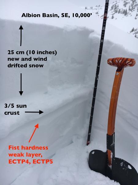
I found weak snow beneath Tuesday's sun/heat crust, with the new wind blown snow enough weight and enough of a slab that I was getting full propagation beneath the crust, and this makes me a bit suspect of the southerly facing slopes. Snow running above and on the crusts could go further and faster than expected. If a slide breaks below the crust, it has the potential to be wider than expected.
Sun crusts are frustrating because they can vary in thickness and strength with even subtle changes in aspect and slope steepness. The good news is it will be easy to quickly dig down to this layer to evaluate it.
Winds were getting well down off the ridge lines and into open bowls and the canyon bottom. Winds are channeled by the terrain. While the general wind direction today was from the south, the winds observed below were blowing from west to east, loading snow mid slope and along the sides of sub ridges. The strong forecast wind speeds for overnight mean wind drifts can be well off the ridge lines in places.

Today's Observed Danger Rating
Considerable
Tomorrows Estimated Danger Rating
Considerable


