Observation Date
2/15/2019
Observer Name
T Diegel D Gustafson
Region
Salt Lake » Big Cottonwood Canyon » Mineral Fork
Location Name or Route
Mineral BCC
Weather
Sky
Broken
Weather Comments
pretty mellow weather today, but clearly there had been lots of wind. Evelyn suggested going to sheltered trees, but we...didn't quite follow that advice.
Snow Characteristics
New Snow Density
High
Snow Surface Conditions
Wind Crust
Melt-Freeze Crust
Snow Characteristics Comments
a variety of crusts present: up to about 8300 it was a melt-freeze crust due to the high freezing level, and above that in the exposed (ie barely treed) terrain there was wind crust.
Red Flags
Red Flags
Heavy Snowfall
Wind Loading
Red Flags Comments
We stayed on lower-angle slopes due to the wind slabs that we felt like we were traveling on, and didn't get close to the higher, steeper terrain due to the potential for remote triggers that seem like can be more common on windslab development, and the fact that the snowpack seems to be going through a lot of rapid changes lately. That said, we had no whoomphs and our quick pits indicated fairly decent bonding of the various layers, but there were clean shears between the layers.
Avalanche Problem #1
Problem
Wind Drifted Snow
Trend
Increasing Danger
Problem #1 Comments
the wind slab was stiff enough that it was carvy foam skiing and not breakable, but that same stiffness made it a little unnerving getting on anything other than pretty low angle. The snow was actually a little better for skiing on the southern aspect, but given the video of the LCC slide yesterday we were wary enough of it that we dug a real pit on a SW facing slope to see what was going on, and found...not much (see video).
Avalanche Problem #2
Problem
Wet Snow
Trend
Decreasing Danger
Problem #2 Comments
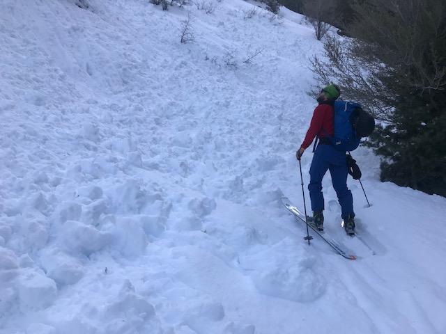
My concern about low elevation snow from yesterday seemed to be somewhat well-founded; the Mineral trail was pretty much covered with big debris where it had slid from the steep slopes above (see pic). And even today when we exited the snow down low was getting soupy, which is not surprising considering that the temp at the TH was 37 when we finished. Given the forecasted low temps, however, this danger will likely be alleviated (locked up, or insulated?).
Video
The most important thing about this is not what it was today, but what it'll be after tonight's storm. I have no idea. Is the crust strong enough to "hold up" the new snow? will the new load (sounds like pretty low density) be enough to pull out the shears that we saw a couple of feet down? will the new snow bond to the melt-freeze crust below 8300 and/or the wind crust above that level? or to the non-windjacked snow in sheltered areas? (the latter seems likely, the two formers....probably? but with additional wind?
As our friend Peter Donner likes to say, we need to pray for More Snow and Less Wind. clearly the "more snow" part has worked, but more people need to pray harder for "less wind"....
Today's Observed Danger Rating
Moderate
Tomorrows Estimated Danger Rating
Considerable