Observation: Big Cottonwood Canyon

Observation Date
2/14/2019
Observer Name
Greg Gagne
Region
Salt Lake » Big Cottonwood Canyon
Location Name or Route
Park City Ridgeline
Weather
Sky
Overcast
Wind Direction
Southwest
Wind Speed
Strong
Weather Comments
Winds diminished for a few hours mid-morning, but then picked up about mid-day.
Snow Characteristics
New Snow Depth
12"
New Snow Density
High
Snow Surface Conditions
Powder
Damp
Snow Characteristics Comments
Difficult to determine actual depths of new snow as it was so dense. Fortunately the density kept you on top of the inverted snowpack, and you were able to travel and ski in the top 5-10 cms, providing excellent travel and ski conditions. Dense storm slabs were not sensitive to stability tests, and the few wind drifts we encountered were also not sensitive.
Red Flags
Red Flags
Recent Avalanches
Heavy Snowfall
Wind Loading
Poor Snowpack Structure
Red Flags Comments
Plenty of red flags heading up Big Cottonwood with numerous road side sluffs and storm slabs from the dense snow and low-elevation rain. Above about 9000' the air was cold enough that the effects of wet snow weren't present and it was just a dense, unreactive storm slab.
Avalanche Problem #1
Problem
Wind Drifted Snow
Trend
Same
Problem #1 Comments
Persistent winds out of the south/southwest drifting leeward aspects, with very large cornices. In some places the cornices are overhanging the slopes below by about 10'.
Comments
Overall quick stability tests were showing overall stable conditions with storm snow unreactive to stability tests, and the few wind drifts we encountered were also unreactive. However, the rapid amount of loading of snow/water and wind should prevent anyone from venturing onto steeper terrain, and fortunately the lower-angled slopes are riding quite well. Am expecting with colder temperatures forecasted beginning Friday, the snowpack should begin to lockup and stabilize quickly.
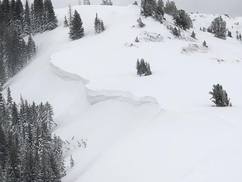
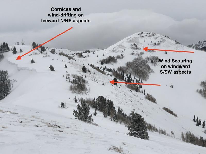
Photos of cornices and the effects of wind scouring and drifting near Scotts Peak along Park City ridgeline.
Today's Observed Danger Rating
Considerable
Tomorrows Estimated Danger Rating
Considerable