Observation: Snake Creek

Observation Date
2/11/2019
Observer Name
B
Region
Salt Lake » Big Cottonwood Canyon » Brighton Perimeter » Snake Creek Pass
Location Name or Route
Snake Creek Canyon
Weather
Sky
Clear
Wind Direction
Northwest
Wind Speed
Light
Weather Comments
High end W to WNW Light category wind speeds with Light to Moderate wind blown and or transport observed on ridge lines and peaks from 9600 feet up to the highest elevations. Temperatures remained in unseasonably cold regimes with single digits to low teens readings.
Snow Characteristics
New Snow Depth
14"
New Snow Density
Medium
Snow Surface Conditions
Powder
Wind Crust
Snow Characteristics Comments
Early morning riding was slow and sticky on low angle slopes due to the frigid temperatures. As the day burned on the riding appeared to speed up, and on slopes with angles 30 degrees and greater the riding was excellent in areas without any signs of wind damage and or loading.
Red Flags
Red Flags
Recent Avalanches
Wind Loading
Poor Snowpack Structure
Red Flags Comments
Poor snowpack structure appeared to be relegated to variable depths of wind deposits, and fresh wind loading that was observed throughout the day as previously cited above. Multiple recent avalanches appear to indicate there may still be potential for reactive wind slabs in very steep N and E facing very steep terrain.
Avalanche Problem #1
Problem
Wind Drifted Snow
Trend
Increasing Danger
Problem #1 Comments
See above, and with the forecast for increasing SW winds for Tuesday, this issue may escalate over the next 48 hours, and especially by Wednesday when we appear to be receiving more dense snowfall.
Avalanche Problem #2
Problem
Cornice
Trend
Increasing Danger
Problem #2 Comments
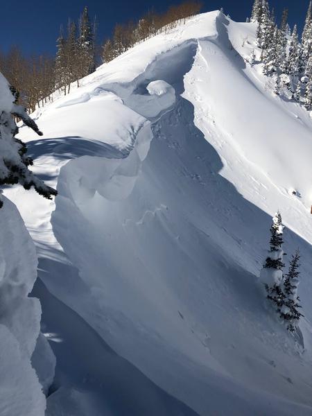
See photo of an example of a large overhanging cornice observed on the NE facing ridge of Caribou Canyon. And, as with the potential escalating for the Wind Slab Problem over the next 48 hours, it appears that Cornice issues may continue to help trigger more avalanches with the arrival of the next series of storms.
Any of these above cited Problems continue to have the potential to trigger deep slides into old buried persistent faceted mid pack and basal layers.
The winds today appeared to be escalating the Danger only in very isolated locations, and as a result, no natural activity seemed likely. For this reason, the Danger/Hazard appeared to be a high consequence Moderate. Over the next 48 hours, the forecast for increasing winds with abundant snow available for transport most likely will elevate the Danger and make it more widespread. By mid day on Tuesday if the forecast for the winds validates, the Danger may be Considerable with naturals possible.
Today's Observed Danger Rating
Moderate
Tomorrows Estimated Danger Rating
Considerable