Observation: Park City Ridgeline

Observation Date
2/7/2019
Observer Name
Bruce Tremper
Region
Salt Lake » Park City Ridgeline
Location Name or Route
Scott's Peak - South Monitor - No Name
Weather
Sky
Scattered
Wind Direction
West
Wind Speed
Moderate
Weather Comments
Yikes. Very cold in the morning with ridge top temperatures perhaps -5 F and a moderate wind from the west. Clearing by mid day to beautiful bluebird and temperatures thankfully warming.
Snow Characteristics
New Snow Depth
5"
New Snow Density
Medium
Snow Surface Conditions
Powder
Snow Characteristics Comments
The storm finished with some lighter powder on top of the dense new snow from the past few days. Ridge top winds made some shallow wind slabs but in wind protected areas it was good turning conditions.
Red Flags
Red Flags
Recent Avalanches
Wind Loading
Cracking
Poor Snowpack Structure
Red Flags Comments
See the attached photo. Since there's no box for a freeform discussion of many snow profile tests, I'll include some here. I was working a Pro Level II avalanche class and here's a summary of the 15-or-so snow profiles dug by the students in 3 groups on various slopes--NW, N, E and SE facing slopes, mostly 9,000-10,000' on South Monitor, the Scott's Hill and the ridgeline to No Name Bowl. Once again, most of the snow profile tests were not particularly reactive. In most places, you could find the Feb 2 interface between the old and new down about 40-70 cm, composed of near surface faceted snow and occasional pockets of surface hoar. The tests were a mix of some propagations and no propagations. Most propagations required quite a bit of force 18-30 taps on ECT. We could occasionally get a propagation on the basal faceted layer near the ground but it generally took hard blows on an ECT (28-30) The only exception was on a SE facing slope at mid elevation thinner area that propagated on 15 taps, as I recall. Of course there was also some shears in the upper snowpack from recent wind slabs.
Avalanche Problem #1
Problem
Wind Drifted Snow
Trend
Decreasing Danger
Problem #1 Comments
The 5 inches of snow overnight combined with wind created some shallow, easy to trigger wind slabs in steep terrain. Mark White's excellent observation today discussed one small one that he was able to trigger.
Avalanche Problem #2
Problem
Persistent Weak Layer
Trend
Same
Problem #2 Comments
There is still some lingering concern with two different persistent layers, the Feb 2nd interface between new and old snow on near surface faceted snow and occasional surface hoar. Also, there is lingering concern about the basal depth hoar layer. There was several results from explosive work at ski areas. Repeater slide paths are probably the most suspect.
Comments
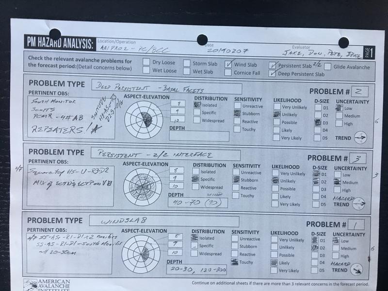
I was working a Pro Level II class today and this is a photo of the worksheet produced jointly by all the instructors at the end of our field day. What more could you ask for? My general feeling is that we just got walloped with a huge storm with lots of water weight. It seems like most of the avalanche activity was in heavily wind loaded, steep slopes near ridges and some deep releases in repeater slide paths. In the other terrain, the same weak layers are still present but most of our snowpit tests had a mix of no propagation or propagation with relatively strong force. I would definitely continue to avoid steep slopes especially ones with lots of wind deposits during the storm. For instance, we skied out to No Name Bowl and No No Name Bowl to take a look at them. They had not slid and they did not seem to have much wind drifted snow but there was no way any of us wanted to mess with it. Same with all the other unslid slopes along the Park City ridgeline. As Drew Hardesty says, "Persistent weak layers require equally persistent patience."
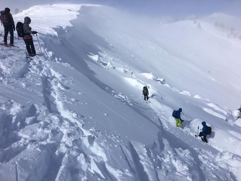
Of course, we had to take a look at the huge avalanche in South Monitor. See Mark White's excellent observation and photos from today.
Today's Observed Danger Rating
Considerable
Tomorrows Estimated Danger Rating
Considerable