Observation Date
1/16/2019
Observer Name
Hughes/ Kikkert
Region
Uintas » Upper Weber Canyon
Location Name or Route
Upper Weber Canyon
Weather
Sky
Obscured
Precipitation
Light Snowfall
Wind Direction
South
Wind Speed
Moderate
Weather Comments
Light winds in the morning but picking up as day progressed and noticed transporting snow around Noon. Snow was in and out throughout the day.
Snow Characteristics
New Snow Depth
5"
New Snow Density
Low
Snow Surface Conditions
Powder
Red Flags
Red Flags
Wind Loading
Poor Snowpack Structure
Red Flags Comments
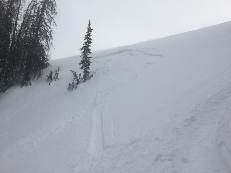
Minor cracking noted within new wind drifted snow, small soft slabs off the high lee ridges 4-5 inches in depth. Poor structure noted in many areas traveled. Plenty of faceted grains within the snowpack but not much of a slab was found in our travels today. See pit profile below. Add an inch or two water to this fragile snowpack and we may see some decent size avalanches.
Avalanche Problem #1
Problem
Persistent Weak Layer
Trend
Increasing Danger
Problem #1 Comments
See Red Flags comment and Snow pit below.
Avalanche Problem #2
Problem
Wind Drifted Snow
Trend
Increasing Danger
Problem #2 Comments
There is plenty of snow available for transport and weak surface snow for wind drifted snow to fail on. Add more snow and wind with this next storm system and we could see these wind slabs grow substantially.
Snow Profile
Aspect
North
Elevation
9,400'
Slope Angle
31°
Comments
Fragile snowpack. Main layer of concern is 80-76 cm. Could see slab failing on this layer and then stepping down to weak layers lower down in the snowpack. Time to stay out of and underneath steep wind drifted terrain especially northern aspects with the upcoming weather.
Starting out with moderate danger in the morning and potentially moving to considerable through the day as the storm moves into the area.
Today's Observed Danger Rating
Moderate
Tomorrows Estimated Danger Rating
Considerable