Observation Date
1/3/2019
Observer Name
B
Region
Salt Lake » Little Cottonwood Canyon » Snowbird periphery » Mary Ellen
Location Name or Route
Lower Mineral Basin/Mary Ellen Gulch
Weather
Sky
Clear
Wind Direction
Northwest
Wind Speed
Calm
Weather Comments
Temperatures in the early am still cold and in the middle teens with rapid warming by the mid morning hours. Intense solar for this time of year. Calm winds with barely any breeze until mid afternoon with the NW winds hitting the high end of the light range. At this point in the mid to late afternoon hours there was light wind blown and or transport observed on the highest ridge lines.
Snow Characteristics
Snow Surface Conditions
Faceted Loose
Wind Crust
Melt-Freeze Crust
Damp
Snow Characteristics Comments
Lower Mineral below Pagen Basin, as well as the upper reaches of Mary Ellen Gulch were extremely wind damaged even in areas one would expect to find patches of protected old powder lying around. Beyond variable, very challenging riding conditions. Lower Pagen Basin had some areas with decent/acceptable old powder in the most protected forested areas. Intense solar got SSE, S and SW aspects damp during the day with M/F crust ensuing the minute the low angle sun moved around the compass and left those aspects. Glazed M/F crusts were observed in these areas. Wind damage was the rule not the exception.
Red Flags
Red Flags
Recent Avalanches
Wind Loading
Rapid Warming
Poor Snowpack Structure
Red Flags Comments
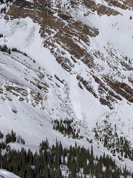
Observation from Airplane Peak indicative of the transport previously cited above. Yet, the biggest concern for the day was widespread Loose Wet Avalanches on southerly faces, and especially those with slope angles > 35 degrees. See photo from the south side of Sugarloaf/Devils Castle. And it appeared that one small pocket of Wet Loose stepped down to a D1 Wet Slab mid slope down below Devils Castle. Poor snowpack structure widespread in Lower Mineral Basin with HS ranging from 1 meter down to 40 cm in areas that had been wind stripped. DH in the shallow areas at least 2.5mm in size and well developed. In areas with HS between 60 and a meter the snowpack is quickly sandboxing and with areas that were totally unsupportable. In all areas there was at least a wind skin of 1 to 3 cm, and there was intense faceting occurring directly below these widespread wind deposits. It was very difficult to escape these thin/old/stubborn wind slabs. The biggest take home would be the weak snow near the surface ranging from on the surface to 10 cm down.
Avalanche Problem #1
Problem
Wet Snow
Trend
Increasing Danger
Problem #1 Comments
With the temperatures forecast to rise at least another 7 degrees on Friday this issue may continue to be active, and in areas where there are facets resting below the old M/F crusts, small pockets of Wet Slab may be an issue during times when the steep southerly faces are receiving the intense afternoon solar.
Avalanche Problem #2
Problem
Wind Drifted Snow
Trend
Decreasing Danger
Problem #2 Comments
Despite being stubborn and shallow, the potential to find a wind slab in the highest steepest terrain was possible.
This was just one photo of the activity we were observing, by late afternoon it was widespread. Of note, the weak snow observed on the shady aspects is not a concern at this point in time, yet it would be advantageous to detail these suspect areas once we do begin to get significant loading events.
Today's Observed Danger Rating
Moderate
Tomorrows Estimated Danger Rating
Moderate