Observation: Cottonwood Ridgeline

Observation Date
3/18/2018
Observer Name
Hardesty, Wilson
Region
Salt Lake » Little Cottonwood Canyon » Cottonwood Ridgeline
Location Name or Route
Cottonwood Ridgeline
Weather
Sky
Obscured
Precipitation
Moderate Snowfall
Wind Direction
Northwest
Wind Speed
Light
Weather Comments
Light with occasional moderate northwest winds; minor drifting only along ridgelines. Cold. Waves of higher PI. Snowed all day. No wind or sun effect heading into tomorrow.
Snow Characteristics
New Snow Depth
2'
New Snow Density
Low
Snow Surface Conditions
Powder
Snow Characteristics Comments

Transcendent. Right side up. Reminds us why we love skiing in the first place. I did something today that I almost never do. I lapped a run. I'll explain why below.

  • I find it uninteresting. I generally prefer more terrain than more laps.
  • A few years ago, an old supervisor chided one of the forecasters on social media for showing ski tracks in perfect powder. So I clocked out for the extra run.
  • Terrain choices for my personal and government risk tolerance have diminished. A couple of years ago, CMH ski (and old WPG) guide Roger Atkins proposed a common language for how an guide service or individual might approach terrain: they might step out, step back, remain status quo, open season, entrenched - you get the idea. With 4"+ of SWE and southerly winds since Wednesday, it seems appropriate to be stepping back to low angle terrain. It was still phenomenal.
Red Flags
Red Flags
Recent Avalanches
Heavy Snowfall
Wind Loading
Poor Snowpack Structure
Red Flags Comments
None noted today: avalanches, cracking, collapsing, but poor structure plus aforementioned significant loading since Wednesday is enough.
Snow Profile
Aspect
Southeast
Elevation
9,400'

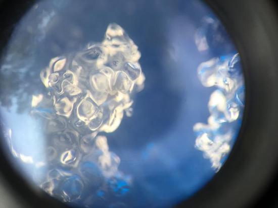
Profile on 9400' SE facing HS roughly 150cm. Stable snow. Snow is isothermal at and beneath the noticeable Feb 18th dust/crust layer found at roughly 50cm. ECTX. ECT shovel shear hybrid test elicited full propagation on loose 3-4mm melt freeze clusters above the 2/18 dust crust.

Plenty of loose snow to move with provocation with sun and wind over the next few days if that's how the weather plays out. Haven't looked at the models but some earlier hints this morning at subtropical moisture tap look to keep things interesting.

Last year was the Year of the Cornice. They really haven't been much of an issue until the last few days. They are growing considerably along the high ridgelies...and as Nalli's ob from yesterday reveals what we expected - that they are enough of a thump to trigger old snow avalanches in thinner/repeater terrain.

Today's Observed Danger Rating
None
Tomorrows Estimated Danger Rating
None