Planned Website Outage: The UAC website will be down for maintenance on June 17 from 2:00 - 7:00 PM MT.

Observation: Cottonwood Canyons

Observation Date
2/15/2018
Observer Name
Greg Gagne / Bob Frey
Region
Salt Lake » Cottonwood Canyons
Location Name or Route
Silver Fork/ Hideaway
Weather
Sky
Obscured
Precipitation
Moderate Snowfall
Wind Direction
West
Wind Speed
Moderate
Weather Comments
Sustained winds out of the west/northwest with drifting onto leeward aspects. Periods of S2 snowfall.
Snow Characteristics
New Snow Depth
16"
New Snow Density
Low
Snow Surface Conditions
Powder
Wind Crust
Snow Characteristics Comments

Difficult to measure snowfall totals with so much drifting, but about 30-45 cms (12-18") in upper Cottonwoods, with some drifts along the ridges approaching 60 cms (2').

Red Flags
Red Flags
Recent Avalanches
Heavy Snowfall
Wind Loading
Cracking
Poor Snowpack Structure
Red Flags Comments
Lots of cracking in fresh wind drifts along upper elevation ridgelines.
Avalanche Problem #1
Problem
Wind Drifted Snow
Trend
Decreasing Danger
Problem #1 Comments

Plenty of drifting with cracking in soft slabs. At best we were able to pull out some class 1 soft slabs descending onto northwest aspects in East Bowl. These were not breaking out widely, and unless winds increase overnight, would expect these drifts to be less sensitive on Friday.

Avalanche Problem #2
Problem
New Snow
Trend
Same
Problem #2 Comments

Able to get sluffs running in the top of the storm snow on steeper aspects. Very low-density (5%) storm snow likely to remain sensitive on Friday.

Comments

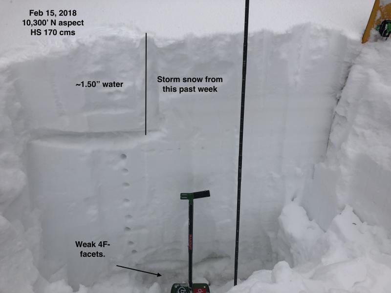
Third Problem remains persistent slabs. Thursday/s storm added about an inch of water weight to the snowpack. This is on top of the 0.5-0.75" from this past Saturday and Monday storms. Although the snowpack has strengthened over the past few weeks, weak faceted snow is still found at mid and upper elevation slopes facing north through east. Photo below shows the storm snow from this past week, which added about 1.5" of water weight to the snowpack.

Video discussion as well.

Video

Solid moderate hazard today. Predictable sensitive wind drifts in upper elevation terrain, and sluffing on steeper rollovers. Ignoring deep weak layers down near the ground, today's avalanche problems were manageable with effective ski cuts.

Today's Observed Danger Rating
Moderate
Tomorrows Estimated Danger Rating
Moderate