Observation: Humpy Creek

Observation Date
1/25/2018
Observer Name
CBrown
Region
Uintas » Bear River Ranger District » Humpy Creek
Location Name or Route
Humpy Creek
Weather
Sky
Overcast
Wind Direction
South
Wind Speed
Moderate
Weather Comments
Most of the day had moderate winds with strong gusts. Winds picked up in the afternoon as the cold front approached. Cold front arrived around 2:00 to 3:00 PM with snow begining at 4:00 and increasing after.
Snow Characteristics
Snow Surface Conditions
Powder
Dense Loose
Faceted Loose
Wind Crust
Snow Characteristics Comments

The winds really did a number on the snow surface conditions. Very protected slopes on shady slopes held nice settled powder, but most of the powder was blown to WY.

Red Flags
Red Flags
Recent Avalanches
Wind Loading
Poor Snowpack Structure
Red Flags Comments
Observed 2 size 1 natural windslab avalanches on NNE aspects around 10,400'. Triggered a sensitive size 1.5 wind slab avalanche on NE. The cranking winds today may have been sublimating some of the snow, but additional loading was still taking place. Poor structure still remains in many places.
Avalanche Problem #1
Problem
Wind Drifted Snow
Trend
Increasing Danger
Problem #1 Comments

Wind Slab was the most apparent avalanche problem today. Surprised to see that none of the observed or triggered wind slabs stepped down into the PWL's. Would expect these to continue to build and form into hard slabs. Today they were on the boarder of HS and SS.

Avalanche Problem #2
Problem
Persistent Weak Layer
Trend
Increasing Danger
Problem #2 Comments

Given the observed weak structure with a cohesive slab on top of weak persistent grains this is still the most concerning problem in my mind. For the moment it seems dormant, but with the new snow and additional wind loading we may see this become an active problem again. Low-medium probability, with high consequence.

Snow Profile
Aspect
North
Elevation
10,400'
Slope Angle
33°
Comments

In the above pit I found one of the deepest pack's I have seen to date in the Uinta's. Surprised by the depth and strength. No results on CT or ECT and snow seems to be gaining strength. I believe this is representative of the full season snow pack in this area, and wouldn't be surprised if some of the ski slopes in this area have avalanched previously leaving a shallower, weaker, more reactive pack, but encouraging none the less.

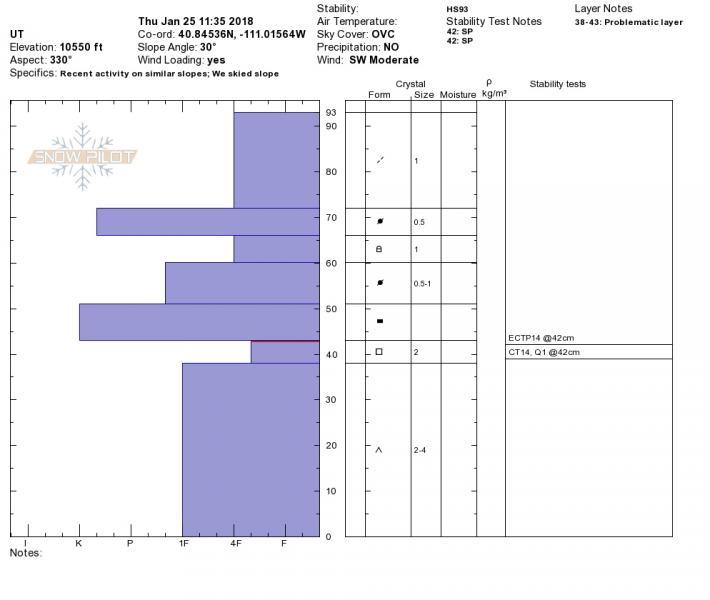
Below is a whole different story. Shallow weak and reactive. Not to far from the above pit and similar aspect and elevation.

It seems in many places the starting zones are shallower and weaker, or barely existent maybe due to wind stripping. But once you get down on the slope a little ways there is a much deeper pack, whether that is 100 cm and still scary or 175 cm and more stable. I am going to be paying attention to my HS in areas where the persistent slab exists to see what is going on. Some of these deeper packs on upper elevation northerlies may be turning the corner and strengthening, but more observations will be needed.

Today's Observed Danger Rating
Considerable
Tomorrows Estimated Danger Rating
Considerable