Planned Website Outage: The UAC website will be down for maintenance on June 17 from 2:00 - 7:00 PM MT.

Observation: Park City Ridgeline

Observation Date
1/15/2018
Observer Name
Paradis
Region
Salt Lake » Park City Ridgeline
Location Name or Route
Park City Ridgeline
Weather
Sky
Clear
Weather Comments
Calm and relatively warm for January. Nice day to be outside.
Snow Characteristics
New Snow Depth
4"
New Snow Density
Medium
Snow Surface Conditions
Dense Loose
Snow Characteristics Comments

Much of the lower angle terrain adjacent to the Canyons was well tracked, including Beartrap, Desolation Ridge, Powder Park.

Anything with a bit of southern exposure was pretty crusty. Untracked areas that did not get sun were settled snow with lots of surface hoar to ski through.

Red Flags
Red Flags
Recent Avalanches
Poor Snowpack Structure
Red Flags Comments
Red flags are still present but less obvious. Yesterday I noted two small collapses but didn't have any today. The two red flags that stood out to me were A) a recent small avalanche that maybe happened yesterday or Friday (see photo below) and B) you can still easily push your arm through the lower faceted portion of the snowpack.
Avalanche Problem #1
Problem
Persistent Weak Layer
Trend
Decreasing Danger
Problem #1 Comments

Snow pits, pushing your pole into the snow, or stepping out of your skis quickly reveals the wrong structure with denser snow over weaker snow. Prior to this most recent round of storms, it seemed like most of the snow was not-cohesive, facets or low density new snow. Now we have more of a cohesive slab which is capable of producing well connected slab avalanches.

Snow Profile
Aspect
North
Elevation
9,300'
Slope Angle
17°
Comments

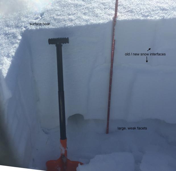
Snow pit tests did not provide really clear information today. This many days out from a storm, I think sometimes it gets more difficult to observe clean planar shears. Two things stood out to me,

  • It was interesting to see two different old / new snow interfaces probably from different parts storms last week.
  • The very weak faceted near that is now about two feet down is of greatest concern. As noted above it was very easy to push your arm entirely through this snow. After an unimpressive ECT result on one of the old/new snow interfaces, it didn't take much effort to pry out a larger cohesive block of snow.

The hole where I was able to push much of my arm into the snow is visible between the shovel and probe.

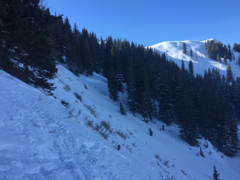
I noticed this mid slope avalanche off Desolation Ridge. It wasn't all that big but was maybe two feet deep and would have pushed you into the trees.

It looked like it happened since the most recent snow on Thursday night so I suspect that it may not have been related to those reported on 1/11 in this area. If it did happen Friday or Saturday, then it is also provides red flag type information about persistent instability after storms.

To me it was also interesting because it broke about half way down off the slope and well within the trees, which often provide a somewhat false sense of security.

Today's Observed Danger Rating
Considerable
Tomorrows Estimated Danger Rating
Considerable
Coordinates